I saw an odd sight while I was sitting in a traffic jam near Kuala Lumpur the other day. Unfortunately I did not have my camera handy so I shall have to describe it. It was an ordinary looking white van, a Hiace or the Nissan equivalent. On the rear window was lettering which read something like ‘SB FUNERAL SERVICES – THE FINAL JOURNEY’. Through the windows I could see a few cushions and plastic flowers. I couldn’t tell if there was a coffin inside or not. Mounted on each corner of the van were large banana leaves which fluttered like flags in the breeze. I wondered which of Malaysia’s many races and religions uses banana leaves as part of their funeral rituals – Tamil perhaps? The van was fitted with an ambulance-style flashing light and siren and the driver was sounding the siren as he negotiated his way to the front of the traffic queue. Then we went through a red light and did an illegal U-turn. Why the hurry?
Category: Malaysia
Kuala Lumpur Butterfly Park & Bird Park
In Kuala Lumpur, a great place to visit is the Lake Gardens, a green lung in the centre of the city which includes a number of tourist attractions such as the Butterfly Park, The KL Bird Park, a deer park, orchid and hibiscus gardens, a planetarium, the Islamic Arts Museum (highly recommended) and the Police Museum.
I took some visitors from overseas to the butterfly and bird parks recently.

The Butterfly Park has hundreds of colourful butterflies fluttering around freely under a huge netting canopy. They also have an impressive collection of beetles, stick insects and other insects as well as koi ponds and tortoises. Tourists from temperate or desert climates particularly appreciate the lush vegetation and the hot and humid air. Well worth a visit even if you have been to butterfly parks elsewhere.
The KL Bird Park is a more impressive attraction covering over 20 acres and said to contain the world’s largest free flight walk-in aviary.

Many of the birds are accustomed to humans and some, such as the peacocks, will allow you to feed them from your hand. It is a good place to practice your bird photography.


Useful Thrifty Tips
Tip #1. If you are a tourist on a budget and not keen to spend the RM45 ticket price (expensive by Malaysian standards), take lunch at the Hornbill Restaurant instead. This restaurant is perched above the edge of the Bird Park, underneath the aviary netting so if you sit outside on the balcony you will be visited by some of the park’s braver birds such as this hornbill:

Indeed if the waiter is slow in clearing your plate, a hornbill might jump on the table to snatch any leftovers. I can recommend the curry dishes together with an ice cold Tiger beer or perhaps a fresh kalamansi juice with sour plums. Delicious! After lunch, if you are still not tempted to part with the RM 45 park entrance fee, you can pop across the street and see the Orchid and Hibiscus Gardens which are free on weekdays.
Tip #2. If you are a foreigner living in Malaysia, show your Malaysian driving license and get into the park at the discounted price of RM20.

Perhentian Islands

I’ve just returned from a few days break at the Tuna Bay Island Resort on the scenic Perhentian Islands which are located a few miles off the Terengganu coast on the eastern side of Peninsula Malaysia.

To get there, we flew on AirAsia from KL to Kota Bharu. It was the sort of hassle-free flight I enjoy. Already checked-in online and with no baggage and no passport control to worry about, we just passed through the security check directly into the departure lounge. A short wait for the flight to be called, then a stroll out to the plane for the 50 minute flight. On arrival at Kota Bharu, we walked straight out into the greeting area where Tuna Bay’s representative was waiting. Then came an hour’s mini-bus transfer through interesting kampungs and rural scenery of Kelantan and Terengganu to the boat jetty at Kuala Besut where we caught Tuna Bay’s speed boat (not so speedy) out to the islands, a journey which took a further 45 minutes.

We were staying on Perhentian Besar (Big) from where we had a good view of the smaller island (Kecil). The Tuna Bay resort comprises 40 or so wooden chalets, fairly basic, but clean and comfortable enough with hot water and aircon. We had connecting rooms which was handy for our family group. Being October, the resort was running an end-of-season promotion so the rates were reasonable (this east coast of Malaysia is affected by the north-east monsoon between November and March causing rough seas and making the islands almost inaccessible by sea and most resorts close down for a few months.)


The resort is sited on a stretch of soft white sand (though speckled with pieces of broken coral) overlooking clear turquoise water and snorkeling is possible right in front of the resort. At low tide you can just walk out to the coral. The abundant fish are friendly and inquisitive, probably accustomed to being fed pieces of bread from the hotel’s breakfast buffet. The Perhentians are a protected area under the watchful eye of the Marine Parks Department. Their list of good practices includes no fins for snorkelers to prevent people from standing on coral or breaking bits off with their fin tips. I can understand their motives but for me snorkeling without fins is not so enjoyable. Despite the Marine Department’s best efforts, the coral in front of the resort has inevitably been degraded and to see more pristine coral we took a boat ride out to Turtle Bay and the D’Lagoon bay on the north east tip of Perhentian Kecil. I didn’t manage to see any turtles (apart from some baby hatchlings in a pond at the D’Lagoon hotel) but there was rich coral life and plenty of colourful fish in the deep clear water.


From the boat you could see various chalet developments dotting the beaches, some scruffy, mostly basic and none particularly luxurious. There was some small scale development going on along the shoreline but the hilly interior of the islands remains largely untouched, coated in thick impenetrable-looking forest. The Perhentians are not quite the unspoilt island paradise that some websites would have you believe but if you are looking for a relaxing no-frills holiday or you want to get your kids away from TV and computer games this could be the place for you.

Seri Menanti

The guide books recommended Seri Menanti Royal Museum as a place to visit just two hours drive from Kuala Lumpur so one weekend I took the family for a look-see. The small town of Seri Menanti is the royal capital of Negri Sembilan state (Seremban is the state capital). Negri Sembilan translates as nine states reflecting the historical 9 fiefdoms which made up the confederation from 1773 onwards. The rulers of this state are of Minangkabau stock having migrated from western Sumatra about six centuries ago bringing their distinctive architectural style with them.
This building was constructed between 1902 and 1908 as a royal palace to replace an earlier one which was destroyed by the British in 1875. The most famous fact about this four storey structure is that it was apparently built without the use of a single nail. It served as the official residence of the Negri Sembilan royal family until 1931. It was made into a museum of royal regalia in 1992 and contains displays of costumes, weapons, furniture and other paraphernalia.

The town itself is home to the Royal Seri Menanti Golf & Country Club which is surrounded by three palaces including the current official residence of the ruler of Negri Sembilan. There is also a Royal Mausoleum, Royal Mosque and a hotel.
It was a pleasant day out and worth the visit.
Putrajaya – Four Parks Walk
Putrajaya, the federal administrative capital of Malaysia and the place I call home, is a green town. Often described as a City in a Garden, around 40% of its 4500 hectare area has been set aside for parks and green spaces. Putrajaya has a population of around 70,000 (planned to increase to 330,000 eventually). During office hours the population surges to 100,000 or so as hordes of civil servants commute into the city from outlying areas. At weekends though the streets are fairly empty and the parks are completely deserted. I don’t know where the 70,000 residents go at weekends – perhaps to the malls – but it seems they are not keen on walking which is a pity because Putrajaya’s parks are very beautiful. Last Saturday I took a circular walk lasting 4 hours which included four of Putrajaya’s many parks. I had the place to myself as usual.

Taman Putra Perdana
This park lies in the heart of Putrajaya on a low hill affording fine views over the city. At the highest point sits the Istana Melawati, a royal retreat for the King and the second-ranked national palace after Istana Negara in Kuala Lumpur. The Shangri-La Hotel is located next door.


Taman Wawasan
Crossing the Putra Bridge on Putrajaya’s main thoroughfare I was able to stand in the middle of the road to take this photo without fear of being struck by traffic.

A happy couple in traditional costumes was posing for wedding photos.

Leaving the road I entered the second park, Taman Wawasan. This park has plenty of picnic spots, gazebos, jogging tracks, cycle paths and even a pebble beach though I am not sure I would brave enough to swim in the lake having spotted some rather large lizards cruising around.


Taman Warisan Pertanian
Nearby is the Agricultural Heritage Park which highlights the important role agriculture plays in Malaysia’s economy. This is the only park where you have to pay an entrance fee (cheap). The park contains rubber trees, oil palms, coffee, fruit and cocoa trees and has a demonstration of how rubber is produced.


At the entrance is an outdoor eating area including a branch of the famous Kajang Satay.
Presint 16 Promenade
Close to the Agricultural Park is the start of the promenade which runs along the lake shoreline all the way back to the Putra Mosque via the Alamanda shopping mall. On some islands in the lake, isolated from humans, live colonies of egrets, night herons, grey herons, green herons, purple herons, cattle egrets, black crown neck herons, painted storks and cinnamon bitterns.

This group of painted storks seems oblivious to the threat posed by the large monitor lizard behind them. Judging by its fat tummy, perhaps it has already eaten. Or maybe its a female lizard about to lay eggs on the island and the storks are hanging around to dig up the eggs and eat them as soon as the lizard leaves. Who is the predator here?

For information on two more of Putrajaya’s lovely parks, Taman Wetlands and Botanical Gardens, you can take a look at my website http://www.malaysia-traveller.com/national-parks.html
Paya Indah Wetlands – Hippos & White Elephants
UPDATE: I visited Paya Indah wetlands again recently (June 2011) and there have been some changes and improvements. See my website http://www.malaysia-traveller.com/paya-indah-wetlands.html for more details.
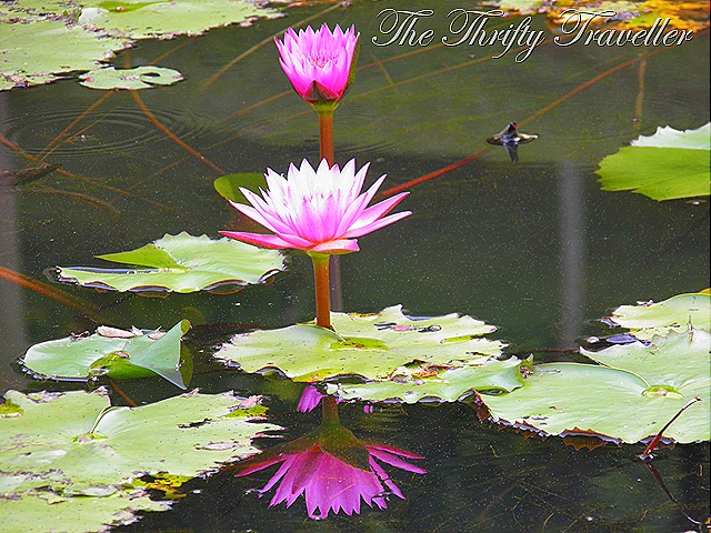
Paya Indah Wetlands, located some 50km from Kuala Lumpur, not far from Putrajaya, is described on an official government website as Malaysia’s premier eco-tourism park covering 3,100 hectares. This may have been the ambition when the park was first established but in reality it is a bit of an odd place. Admittedly, the park’s 14 man-made lakes (presumably left over from earlier mining activity) contain some attractive lotus plants and water lilies. Paya Indah translates as ‘beautiful swamp’ and in places it lives up to its name. The wetlands also serve an important function as home to a number of bird, insect and plant species. But as a tourist attraction, the park doesn’t really come up to scratch. A lot of money must have been spent on constructing the ticket office, restaurant, parking, toilet facilities etc. There are even some nice looking chalets for rent but everything seemed to be closed or abandoned and we pretty much had the place to ourselves. A friendly chap at the entrance told us about the main attractions which seemed to be a few hippos and crocodiles. This handsome hippo (from Botswana) was sociable but not really what you expect to see in a wetland eco-park. Some more work is needed to turn Paya Indah into a first class facility otherwise it risks becoming a white elephant to add to the hippos and crocs.

Klang Gates Quartz Ridge

Running down the eastern outskirts of Kuala Lumpur is an impressive range of steep grey cliffs, 14km long and no more than 200 meters wide. These grey outcrops are made of quartz and the feature is said to be the largest pure quartz dyke in the world, formed millions of years ago by tectonic buckling of the earth’s crust. The most spectacular section runs for about 5km near the Zoo Negara and goes by the grand title of Klang Gates Quartz Ridge or Bukit Tabur in Malay.

Yesterday I took my sons for a hike in this area. Thanks to an excellent website called Nature Escapes http://www.nature-escapes-kuala-lumpur.com/Klang-Gates-Quartz-Ridge.html we had good directions for reaching the starting point of the trail. After a steep ascent up a hillside we walked through the wooded pathway on the spine of the ridge itself before climbing one of the sharp pinnacles along its length. We then retraced our steps back to the starting point – about 2 to 3 hours in total. The path is well marked and signs have been put up signs reminding hikers to take their rubbish home and avoid damaging the rocks and the flora and fauna. The signs seem to have worked because the trail is very clean. Well done Malaysia!


There was no sign of the rare goat-antelope (the serow) which is said to inhabit this environment but does not appear to have been spotted here since 1985. The ridge is also home to many plant species, some of which are rare or unique to this area.

WWF Malaysia’s website says that this valuable geological site deserves to be declared a World Heritage Site and a national monument. Certainly it merits strong protection since it is under threat from urban development. Being so close to the city and offering fine views of KL’s skyline it is prime real estate and residential developments have crept right up to the base of the ridge in places.

In Malaysia, it is often the practice that when a site is being cleared for development, it is really cleared! None of this preserving old trees or designing the development to fit in with the natural contours of the site. Instead it is bulldoze every tree, scrape off every blade of grass (and the topsoil with it), flatten any small hills and fill in valleys to leave a nice level site for building on. (See the orange/brown scar in the photo above as an example.) Hopefully such practices would not be allowed to wreck such a pristine environment as the Klang Gated Quartz Ridge.

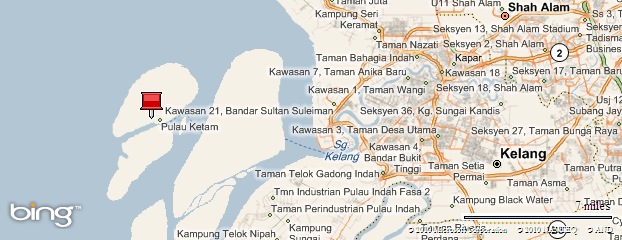
Pulau Ketam (Crab Island)
A few weeks back, I was looking for somewhere different to go for the day and decided to take the family to Pulau Ketam. We drove down to Kelang’s Southport, about 40 km from Kuala Lumpur, parked the car, and found the jetty where ferries depart for Pulau Ketam.


The ferry was shaped like a railway carriage, semi-submerged in the water and showing signs of rust but it was cheap and quite fast once it got going. Personally I prefer my ferries to have open decks and plenty of escape routes whereas this one was more like a floating coffin but it was only a 30 minute journey and the route avoided the open sea. On exiting the busy Kelang harbour, we caught a glimpse of the Star Cruise Terminal at Westport and then entered a narrow estuary with mangrove forest on both sides. Emerging from the muddy waterway, the ferry made a quick dash across a channel before arriving at the jetty on Pulau Ketam.
Pulau Ketam is a low-lying, muddy island fringed with mangrove swamps. It is mainly inhabited by a fishing community of about 8,000 people whose village is made up of quaint wooden houses built on stilts driven into the soft mud. This traditional community migrated from Southern China and settled on the island a couple of hundred years ago to use it as a base to exploit the rich fishing grounds nearby.
At low tide the waters recede to reveal a muddy shoreline teeming with crabs and mudskippers.


There are no cars on the island so as you stroll or cycle along the narrow streets and wooden boardwalks you will get an up close view of how the people live.


The slow pace gives the island a peaceful, relaxing atmosphere which, together with the presence of a number of busy seafood restaurants, makes the island a popular weekend destination for Kuala Lumpurites. The main street from the jetty is lined with shops and restaurants, giving off a pungent aroma of dried seafood and delicious cooking. If you have ever been to Lamma Island in Hong Kong you will be able to imagine this scene. Oyster omelets seemed to be a popular snack food on sale.

Some say the population of Pulau Ketam earns money from fishing, tourism and smuggling. What they are supposed to be smuggling is not clear. I certainly did not see anything fishy going on (excuse the pun!).
It was an enjoyable day out and we shall probably go again.

Mt. Kinabalu vs. Fansipan vs. Rinjani
I recently returned from climbing Mt. Rinjani in Lombok, Indonesia. This was the third in a series of major peaks in South-East Asia, having earlier climbed Mt. Kinabalu in Malaysia and Mt. Fansipan in Vietnam. How did they compare?
-
Height. In terms of height, Kinabalu is the highest, 4,095 metres, followed by Rinjani at 3727m and Fansipan on 3143m. Of course pure height does not the reflect actual metres climbed or the degree of difficulty. The Kinabalu climb began at Timpahon Gate which lies at an altitude of 1,866m. It was more or less a straight up (and down) route so the actual height climbed was 2,229m. With Fansipan, we started at 1,800m (Tram Ton Pass), but almost immediately dipped to 1,700m and then up to 2,200m for the camp. Then a big up followed by some dips and detours as we negotiated the mountain in front of Fanxipan before climbing up to the summit. The total height actually climbed was around 1,593 metres. As for Rinjani, the trek started at 600m, we ascended to the crater rim, 2641m, then down to Segara Anak lake (2,051m) before climbing up to the 2nd camp, 2,638m, then up to the summit, 3,726m, followed by a long march down to the road at 1,156m. The total height climbed was 3,715 metres (more than double Fansipan!). It was also by far the longest distance walked.

Kinabalu, 4,095m -
Difficulty. Kinabalu was probably the least difficult of the 3 climbs because the path was well defined and maintained. Steps and ropes were in place to assist climbers over the tricky spots. Having said that, it was still very hard work. Being the highest of the 3 peaks, people were more likely to suffer from altitude sickness. I found the descent brutal due to the steepness of the path and the endless rough steps over unforgiving terrain which took a toll on my tired knees. Fansipan was probably the second hardest because there was a lot of mud to be trudged through and in places there were huge boulders to be clambered over which was not easy in the wet slippery conditions. The path was poorly defined and maintained. The hardest climb was Rinjani. This was purely due to the final exhausting 1000 meters which involved clawing our way up a sheer bank of soft volcanic ash. It was also the coldest peak of the three, though Kinabalu was also freezing.
-
Views/Scenery. Rinjani had the most beautiful scenery, especially the view from the crater rim. Shame we could not see a thing from the peak at dawn due to thick cloud. Kinabalu had amazing views from the summit. Fansipan involved a lot of hiking through bamboo forests but the view from the top was also worth seeing.

Rinjani -
Porters. The porters on all three climbs were great and showed impressive stamina and skill at climbing great heights despite shoddy footwear.
-
Access. Both Rinjani and Kinabalu had easy access to their starting off points, a couple of hours drive from the closest airport. Fansipan needed an overnight train trip from Hanoi to reach the start of the trail.
-
Certificate. Kinabalu’s park authorities provided an attractive certificate to commemorate the successful climb. For Rinjani, our tour operator provided a certificate of achievement. Unfortunately no certificates were issued for Fansipan.
-
Accommodation/Food. Kinabalu was well organised to handle the large numbers who climb the mountain daily. Hostel accomodation, with hot meals, showers and toilets, was available at Laban Rata (3,720m) where most climbers spent the night before the early morning trek to the summit. The Rinjani climb included two nights in tents,the comfort of which, and the quality of the food, depended on which tour operator you used. Ours was excellent and they even provided a toilet tent in an attempt to at least bury the poo, which unfortunately was strewn all over the campsites. Fansipan had one or two grim shacks where climbers spent the night but the food again was pretty good.

Fansipan -
For more information about climbing Mt. Kinabalu please refer to my website Malaysia-Traveller .com //www.malaysia-traveller.com/gunung-kinabalu.html


Tree House in Malaysia
This interesting house was spotted near Kajang in Selangor, Malaysia.
