Maelmin Henge

Maelmin Henge and Heritage Trail is an outdoor attraction near the Northumberland village of Milfield. There is not a huge amount to see but it is worth a visit if you are in the area. It would also be a good place for a school trip. It comprises a wooden henge and a Dark Age house (both modern reconstructions) and a short trail through a copse and field with a couple of dozen interpretation boards detailing 10,000 years of history from the Palaeolithic era onwards.

This wooden henge is a recreation of the Milfield North Henge which was excavated nearby in the 1970s and carbon-dated to around 2300BC. The original henge would have been used for burials.

An information sign tells us that the Milfield Plain is drier, cooler and sunnier than the rest of UK because it is sheltered somewhat from rain-bearing westerly winds by the Cheviot Hills. They are right about it being cooler, with July mean temperatures of just 14°C. Apparently our Mesolithic hunter-gatherer ancestors used to enjoy temperatures around 2°C higher than today. It seems the current climate change crisis is just taking temperatures back to how they used to be!

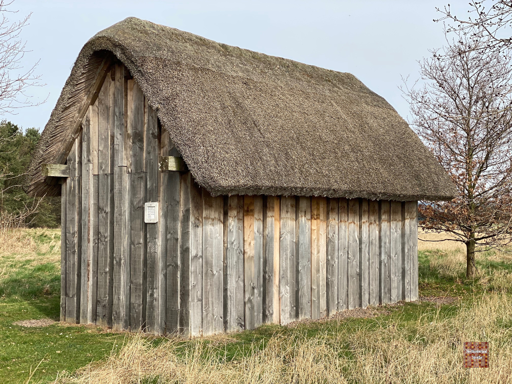
This wooden structure is a full-scale reconstruction of a Dark Age (AD 410-550) house excavated at a nearby quarry. The walls would have been coated in mud and straw to protect against the elements.

You can read more about this place on the official Maelmin Heritage Trail website.

RAF Milfield

There is a memorial and information relating to RAF Milfield in the Maelmin Henge car park.

Maelmin occupies the corner of a former Royal Air Force airfield used by Fighter Command during WWII.

After the war, the hangars were dismantled and the landing strips were removed during subsequent quarrying activity. Taking advantage of the flat terrain, the Borders Gliding Club operates from here.

How to Get to Maelmin Henge

Entrance and parking is free.

You can find the location on this map:

If you zoom out slightly you will be able to make out the remnants of a runway belonging to RAF Milfield.

Nearby

Borders Gliding Club
Ford & Etal

See other Northeast Places of Interest here.

Chopwell – Little Moscow

A century ago, the coal mining village of Chopwell, near Gateshead, was a hotbed of revolutionary socialism and earned the nickname Little Moscow for its strong support of the Communist Party.

The banner of the Chopwell branch of the National Union of Mineworkers bearing the hammer and sickle and portraits of Karl Marx, Vladimir Lenin and Keir Hardie, founder of the Labour Party. Not sure why Lenin has a toilet roll on his desk.

There was a lot of unemployment, poverty and hunger and the working conditions for miners were harsh and dangerous providing a fertile breeding ground for revolutionary ideas. During the 1926 general strike the union flag at the council offices was taken down and replaced with the Soviet Flag. When the Prince of Wales (later King Edward VIII) visited the area in 1929 he expressed sympathy with mining families for the privation and squalid conditions they had to suffer. He received ‘a reet welcome’ from the miners who appreciated his common touch.

The Chopwell Colliery Monument lists the names of 74 miners who died in accidents at Chopwell Colliery from 1782-1966. Ten of them were in their sixties which is quite old for such a physically demanding job.

The last coal pit closed down for good in 1966, taking away the community’s reason for being. Chopwell was classified as a category D village, meaning ‘do not resuscitate’ and it was allowed to decline. But it has hung on and reinvented itself as a dormitory town for those employed in Newcastle or Consett. The village streets may have a rather humdrum appearance but the residents are fortunate to have a 900 acre woodland on their doorstep called Chopwell Wood.

The Red House is a micro-pub in the village rated highly for its friendly atmosphere.

The old pit-head buildings have been demolished and slag heaps levelled. The miners’ rows of terraced houses, once dank, overcrowded and lacking in sanitation, have been upgraded and modernised.

Marx and Lenin Terrace

There is no obvious sign that the revolutionary flame continues to burn brightly but you can still find streets in the village named Lenin Terrace and Marx Terrace and judging by the Chopwell website there is a strong community spirit among the village’s population of 3,000. Another notable street, Fannybush Lane, had to be renamed by the local authority in the 1990s because its street sign kept getting stolen.

How to Get to Chopwell

You can find the location on this map:

Nearby

Derwentcote Steel Furnace

See other Northeast Places of Interest here.

Routin Lynn Waterfall and Rock Carvings

Not far from the village of Ford in Northumberland is a pretty waterfall located in a tucked-away ravine called Routin Lynn.

Actually there is some confusion about the name with various permutations of spelling including Roughting, Roughtin, Lynn and Linn. Google Maps spells it Roughtin Linn but Ordnance Survey (probably the most authoritative source) calls it Routin Lynn. The confusion is not helped by a second waterfall with an almost identical name (Roughting Linn) located 13 miles away near Chatton.

The fall drops about 20 feet into a clear brown pool. I suppose some might be brave enough to take a dip and experience a power shower but seeing as it was mid-winter when I visited I wasn’t tempted.

A small cave might have been used by stone age visitors to the waterfall.

Routin Lynn Rock Art

A short walk away is an outcrop of grey sandstone bearing dozens of cup and ring markings.

Examples of these ancient rock carvings, some thought to date back 4,000 years to the Neolithic period, can be found scattered all over the British Isles and in Europe but their purpose or meaning remains shrouded in mystery. Petroglyph experts have theorised some kind of mystic, ritual or spiritual significance while others suggest they could have served as maps or been connected with astronomy.

I have an alternative theory. Perhaps they were for entertainment to help pass away those long evenings in the days before television. We Britons have always been fond of games. Could these grooves and circles have been used to play an early form of marbles or tiddlywinks?

A thin dusting of snow helps to highlight the patterns and they remind me of targets, perfect for rolling marbles or flicking pellets of sheep dung. Just an idea!

How to Get to Routin Lynn Waterfall and Rock Carvings

The locations marked on this Google map are accurate. The name of the river is Broomridgedean Burn. You can leave your car by the side of the no-through road opposite. For the waterfall, you will see this worn signpost for Routin Linn Farm (different spelling again!). Walk along this farm track for 100 metres until you hear the sound of gushing water off to the left, then follow the rough path through the woods.

Alternatively you could walk to the waterfall from the village of Ford. You can find the route here.

You can read about more Northumberland attractions here.

Hexham Abbey

Hexham Abbey, with its 1300 years of history, is an interesting place to visit. It stands in the heart of the Northumberland town of Hexham, voted in 2019 as the happiest place to live in Britain. It hasn’t always been so happy as the long chronology of the abbey shows.

The first church and monastery on this site was completed in 678 by Bishop (later Saint) Wilfrid who trained as a monk and missionary on the island of Lindisfarne to convert the pagan Anglo-Saxons.

Viking raiders destroyed part of the church in 875 and it was rebuilt and expanded in the 1100s. Scottish raiders attacked, burnt and ransacked the church on four occasions during the 1200-1300s, including by William Wallace ‘Braveheart’. (Mel Gibson didn’t mention that dastardly deed in his film did he!)

Henry VIII’s dissolution of the monasteries saw Hexham’s priory closed and assets seized in 1537. The King gave the priory’s land and monastic buildings to his agent Sir Reynold Carnaby. The church itself was allowed to continue as the Church of England parish church for Hexham.

In 1725 a builder working on the Abbey fell into a sinkhole and rediscovered the Saxon crypt which had been forgotten for hundreds of years.

The crypt, which is is now open to the public, has a Roman feel to it, having been influenced by the catacombs of Rome and being built entirely from recycled Roman stones.

This huge stone was hidden face down as part of the Abbey’s foundation for hundreds of years until it was unearthed in 1881. It was identified as a tombstone of a young Roman legionnaire called Flavinus and dates from the Roman conquest of Britain. It shows a Roman cavalryman trampling on a cowering Briton.

The abbey was restored in 1908 to how it looks today.

The streets around Hexham Abbey have an old world feel. This photo was taken before lockdown – hopefully they’ll still be in business when this thing is over!

This short film tells more about Hexham Abbey’s history and the top things to see.

Saseo Ono Book in Alnwick

Barter Books, Alnwick

Barter Books is a wonderful bookshop in the Northumberland town of Alnwick. It occupies part of the town’s former railway station and is full of cosy corners with open fires and comfy seating where customers can sit down with a cuppa and browse books at leisure.

It even has a model train doing circuits above the heads of shoppers.

Displayed in glass cabinets is a huge collection of valuable antiquarian books including this rare first (and only) edition which caught my eye.

It is a Japanese World War Two propaganda album printed in 1942 in Jakarta featuring cartoons and drawings by Saseo Ono (1905-1954) on sale for a whopping £860. Saseo Ono was a celebrated caricaturist and manga artist whose style was influenced by jazz, American movies and fashion. When war broke out his talents were employed in producing propaganda material for the Japanese war effort and he was sent to Indonesia from 1942-1946.

The colour drawings shown above have captions in Japanese and Indonesian. The one on the left concerns the battle for Kalidjati Airfield in West Java which was captured by Japanese forces on 1 March 1942 despite stiff resistance by a combined British and Dutch force. The caption of the drawing on the right can be translated as ‘when Japanese troops entered the city of Bandung’.

Other illustrations from the book.

Saseo Ono’s other works while in Indonesia included the drawing of erotic images for the entertainment of Japanese soldiers.

One of Saseo’s wartime propaganda posters showing a demon-like Roosevelt sitting atop the Statue of Liberty.

After the war the Japanese people resumed their love of all things American and Saseo Ono was able to get back to illustrating what he liked best such as humorous scenes, fashion and glamourous women.

Typical Saseo Ono Illustration.

When Marilyn Monroe visited Japan in 1954 with her new husband Joe DiMaggio, the famous baseball player, they were mobbed by adoring fans everywhere they went.

Saseo at work wearing a tropical batik shirt.

Saseo Ono was planning to meet Marilyn Monroe, perhaps with the hope of painting her, but sadly for him he died on the very day she arrived in Tokyo. Perhaps the excitement was just too much for him!

Alnmouth – Wicked & Haunted?

Alnmouth is one of the most attractive villages on the Northumberland coast.

View of Northumberland Street, the main drag in Alnmouth.

As the name suggests, it is situated at the mouth of the River Aln. The bigger town of Alnwick, famous for its castle and gardens, is situated about four miles inland.

The village was founded in 1150 and for centuries it was an active port for fishing and the shipment of grain to London and elsewhere. It may have also harboured smugglers and, with ten pubs in the village in the 18th century, visiting preacher John Wesley described it as ‘a small seaport town famous for all kinds of wickedness’.

The Serviceman, an ex-servicemens club with ‘a great atmosphere, cheap drink and friendly faces’.

Alnmouth does not appear to be a den of vice anymore but it is still well served by pubs. I counted at least five which is not bad for a village with only 500 or so permanent residents.

Wesley may have gained his poor impression of Alnmouth from the 17th century Schooner Hotel which has an interesting past and a spooky reputation.. Notable guests, apart from John Wesley, have included King George III, Charles Dickens and actor Basil Rathbone, most famed for his portrayal of Sherlock Holmes. In the 1600s some of the aforementioned smugglers and other dodgy characters found shelter at the inn and murders, suicides and family massacres took place within its walls. The hotel’s website explains ‘ Spirits of withered and demented souls haunt the whole hotel frequently. Apparently, the spirits don’t care about being seen.’ With over 3000 sightings of 60 individual ghosts, the Paranormal Society has named the Schooner the Most Haunted Hotel in Britain.

The Schooner displays a ‘Haunted Hotel’ sign outside. Clearly they consider that its creepy reputation attracts more people than it puts off.

There are plenty of tea rooms and gift shop in Alnmouth.

By the end of the 19th century shifting sands had caused the estuary to silt up. The opening of the railway in the 1840s brought tourism and today Alnmouth continues to be a pleasant and picturesque tourist and holiday home resort.

The taller building here is Hindmarsh Hall, a community run village hall, original built as a granary about 250 years ago.
St John the Baptist Parish Church, opened in 1876. It replaced an earlier Anglican Church on Church Hill on the other side of the estuary which was washed away by a great storm in 1806.

Until the 1960s a ferryman used to row people across the mouth of the River Aln. The ferryman’s old hut has been refurbished and now contains a heritage centre with memorabilia related to the ferryman. It is thought to be the smallest museum in England.

The beautiful golden sand beach at Alnmouth is very popular. These photos were taken in September 2020 (between lockdowns) and it was quite busy by Northumberland standards. Like many of the beaches on this coastline, it is lined with concrete anti-tank blocks, left over from the Second World War where they were intended to slow down any possible German invasion.

A nine-hole links golf course occupies a prime beach front position. Founded in 1869 it is said to be one of the oldest courses of its kind in England.

On the slopes of Bracken Hill, formerly known as Battery Hill, stands a coastal battery built in 1861 to house the Percy Artillery Volunteers. It was modernised during WWII as an anti-invasion measure. The hill is now a mini nature reserve and provides great views of the beach and golf course.

How to Get to Alnmouth

The location is marked on this map.

Nearby Attractions

Warkworth Castle
Amble
Alnwick Castle & Gardens
Edlingham Castle

Find more Northumberland attractions here.

Seahouses

Seahouses is a small holiday town (or large village) on the scenic Northumberland coast about half way between Bamburgh and Beadnell. A former fishing village, it is now best known as the embarkation point for tourist boat trips to the Farne Islands, famous for puffins and other seabirds.

Boat trips to Farne Islands are available all year round if you don’t mind the cold and choppy seas. I’m waiting for a Covid-free summer for my trip.

Seahouses’ fishermen used to join the Scottish fishing fleet to hunt enormous shoals of herring during their annual migration down the North Sea coastline. By the time the fishing fleet reached Seahouses it could number 300 boats and in the 1890s the harbour was constructed to provide shelter for the visiting boats. Cargo vessels used to pick up barrels of salted herrings packed by the village’s ‘herring lassies’ for sale in places like Russia and Germany. The industry declined from the 1930s onwards.

Seahouses has long lured wealthy naturalist, birdwatcher and artistic types but it was not until the 1920s that the village started to attract the bucket-and-spade brigade, thanks to a branch railway line which was in existence until 1951. Although the permanent population is around 1,800 it swells to around three times that number during the summer high season. They are accommodated in numerous B&Bs, self catering apartments, guest-houses, Airbnbs, hotels and a couple of sprawling caravan parks. Thankfully the pristine beaches which stretch for miles either side of Seahouses are vast enough to make the area seem uncrowded.

To be honest Seahouses is not the quaintest fishing village in the country and it has a somewhat workaday look to it but there are a few highlights:

The Swallow Fish Traditional Smokehouse. Like nearby Craster, Seahouses is famed for its smoked fish and this business, established in 1843, is possibly where the modern kipper was invented. Homemade kipper pate is one of their specialties.

The Olde Ship is one of several pubs in the village. There are also three fish and chip shops and a number of other restaurants and cafes.

A couple of tourist boats with late 18th century lime kilns standing on the left.

You can even learn to scuba dive here. Apparently Farne Islands are one of the best places to dive in the UK but personally I’d prefer somewhere a little warmer – Lombok perhaps.

RNLI lifeboat named Grace Darling.

A safe distance away is the Powder House built in 1886 for storing gunpowder used in blasting for the construction of the harbour walls.

The small light house on the jetty flies the Northumberland flag. It started to rain heavily soon after this photo was taken.

How to Get to Seahouses

The location is marked on this map:

Nearby Attractions

Find more Northumberland attractions here.

Flodden Field

The Battle of Flodden Field took place near the village of Branxton in Northumberland on 9th September 1513. It was the largest battle ever waged between armies from England and Scotland and, after a day of mass slaughter, ended in a decisive victory for England and the death of Scottish King James IV, the last reigning monarch to die in battle.

The Flodden Monument sits on a ridge and marks the centre of English battle lines. The plaque reads To the Brave of Both Nations – Erected 1910.

A trail extends around the edge of the battlefield, from the Monument down to the mid ground which, in 1513, was an undrained boggy morass where most of the killing took place and then up to Branxton Hill where the Scottish forces were assembled at the start of the battle. All around the battlefield are information boards explaining the different stages of the battle, the tactics employed, the different weaponry and so on.

This was where the fighting took place. Branxton village is on the right and you may just be able to make out the monument cross on the left.

The course of the battle has been written about extensively and if you are interested you can read about it on the Remembering Flodden website. At the risk of over-simplification my understanding of the battle was that the Scots were brave and ardent as usual but their main weapon was an 18 foot pike which proved to be unwieldy in the boggy terrain compared to the English 8 foot billhook. Similarly the English artillery was lighter and more manoeuvrable than the Scottish heavy guns which were hard to reposition when unexpectedly outflanked by the Earl of Surrey’s army. English longbows also played a decisive role.

St. Paul’s Church in Branxton where the slain of both sides were received after the Battle of Flodden. The Flodden Monument can be seen on the hilltop behind the church. For three hundred years the engagement was known as the Battle of Branxton Moor and was only romanticised as the ‘Battle of Flodden Field’ by Victorian authors and historians during the 19th Century.

A public phone booth in Branxton village was purchased from British Telecom for £1 and repurposed into a Battle of Flodden tourist information kiosk complete with maps, brochures, a three minute recorded audio guide and a donation box. It is said to be the The World’s Smallest Visitor Centre. So while Scotland commemorates its famous victory over England at Bannockburn with a multi-million pound visitor centre, England’s equivalent fits in a phone booth.

The classic British design icon has been put to creative uses all over the world since they ceased to be used as call boxes, for example as a coffee shop, a salad bar, a micro library, an ATM booth, a colour therapy retreat, a cake shop, an art gallery, a bar, a defibrillator booth and even a beach shower. I passed one in Edinburgh recently which was being used by a street-sleeper for keeping his cardboard boxes dry during the day. And they have always been used as urinals by drunks, even when they still had phones in them!

How to Get to Flodden Field

The location is marked on this map.

Nearby Attractions

Ford & Etal
Heatherslaw Light Railway
Heatherslaw Cornmill
Hay Farm Heavy Horse Centre
Cheviot Brewery

Find more Northumberland attractions here.

Ford and Etal

Ford and Etal are a pair of picturesque villages a couple of miles apart in the valley of the River Till in north Northumberland.

Each village has its own castle and they were once bitter rivals but since 1908 they have been united as part of the same estate under the ownership of the Joicey family.

Thought to be the among the prettiest villages in the county Ford & Etal is marketed as a popular tourist destination. Here are some of the attractions.

Ford Village

Ford Castle dates from around 1340. It was frequently attacked by Scottish invaders and was seized by King James IV of Scotland in 1513 in the build-up to the Battle of Flodden which took place a few miles from here. It now serves as an adventure activity centre for school and youth groups and is not open to the general public.

The medieval St. Michael & All Angels church is even older than the castle, though it was partially rebuilt in the 19th century.

The ruin in the field next to the church was once the vicar’s fortified pele tower.

This building, the Lady Waterford Gallery, used to be the village school and now contains a number of murals by Louisa, Marchioness of Waterford who came to live at Ford Castle in 1859. I have not been able to view inside yet due to lockdown restrictions and now it is closed for the winter. Next year perhaps.

Although the history of Ford goes back a thousand years or more, most of the village that we see today was built during Lady Waterford’s time. She was a philanthropist and keen to improve the living conditions of the estate’s workers. Also perhaps, a model village where all the buildings were neat and tidy with no sign of squalor or poverty was the ultimate accessory for the aristocratic estate owner who had everything.

Horseshoe Forge Antiques is housed in the former blacksmith’s forge with its wonderful Hobbit-like horseshoe door.

Ford Village Shop & Tea Room & Post Office.

Etal Village

Etal is even smaller than Ford, comprising one handsome street of whitewashed cottages, a ruined castle, a manor house, a chapel and a few other buildings.

Etal Castle is a similar age to Ford Castle and it too fell to King James IV prior to the Battle of Flodden in 1513 and lapsed into ruin thereafter. It is now managed by English Heritage.

A road fords the River Till at the edge of Etal. The current looked too strong for a safe crossing when I visited.

The Chapel of the Blessed Virgin Mary, with Etal Manor in the background.

The Black Bull at Etal is the only thatched pub in Northumberland. It is managed by the Cheviot Brewery, a real ale microbrewery also located on the Ford & Etal Estate.

The quaint Lavender Tearooms, Village Shop & Post Office at Etal.

How to Get to Ford and Etal

You can find details on the Ford & Etal Estate’s official website.

Nearby Attractions

Flodden Battlefield
Heatherslaw Light Railway
Heatherslaw Cornmill
Hay Farm Heavy Horse Centre
Cheviot Brewery

Find more Northumberland attractions here.

Craster – Kippers, Captains and Castles

Craster is a tiny village (population 305 in 2011 census) and popular tourist destination within the Northumberland Coast Area of Outstanding Natural Beauty.

Craster, Northumberland by Susan Homer

It started life as a fishing village, taking advantage of a natural harbour sheltered by two offshore rock outcrops called Little Carr and Muckle Carr.

JR Bagshawe – Cobles at Staithes

Local fisherman would launch their traditional boats called cobles and brave the dangerous seas in pursuit of herring shoals which were abundant in these waters.

The Jolly Fisherman at Craster

By the 1880s most people in the village were engaged in fishing and the fish curing trade.

Plaque on the harbour wall at Craster

Concrete piers were constructed around 1906 to facilitate the export of whinstone chippings which were quarried from where the village’s car park now stands. The new harbour was funded from the estate of Captain John Charles Pulleine Craster who was killed in Tibet during the 1904 Younghusband Expedition. You can read an interesting account of Captain Craster’s background on this blog.

The unusual concrete bunker structure on the end of the pier was the base for three tall bins which were used for storing crushed stone transported from the quarry by means of an aerial ropeway.

Craster Kippers

Returning to herrings, there used to be four smokehouses in Craster but only one remains, L Robson & Sons, who describe themselves as world famous traditional fish smokers and producers of the legendary Craster Kippers. The smokehouse dates from 1856. It used to be owned by the Craster family but they sold it to the Robsons in 1906 who are now in their fourth generation of ownership.

A smokey fish aroma fills the air

The procedure for making Craster Kippers is to select plump oily herrings and split them lengthways down the middle. This was previously the job of the village’s womenfolk but nowadays is done by machine. The fish are then soaked in brine before hanging on tenter hooks and placing them in the smokehouse where they absorb the fumes of smouldering whitewood shavings and oak sawdust for 14 -16 hours. The result is a succulent, smoky flavoured delicacy with a golden colour.

I am now on tenterhooks to try this Craster Kipper for my tea.

The herrings used to be landed in the village by local fishermen but are now mostly sourced from Norway, a reflection on the diminished state of Britain’s fishing industry.

Dunstanburgh Castle

Craster’s other main attraction, apart from its kippers, is Dunstanburgh Castle, which is a pleasant three mile walk (round trip) from Craster Quarry Car Park. It is one of Northumberland’s most popular walks.

This dramatic ruined castle stands on a rocky outcrop called the Great Whinn and is operated by English Heritage. Construction was begun in 1313 by Thomas, Earl of Lancaster. It was strengthened in the 1380s by John of Gaunt and later played a strategic part in the War of the Roses. It fell into disrepair at the end of the Middle Ages.

We were lucky with the weather considering it was November.
Lilburn Tower at Dunstanburgh Castle.

Artist J.M.W Turner made a painting of this tower.

Craster’s War Memorial all decked out for Remembrance Day 2020.

Find more Northumberland attractions here.