Back in our all-to-brief summer I took the family to see the ruined Harbottle Castle and the mystical Drake Stone situated in the scenic Coquetdale region of Northumberland.
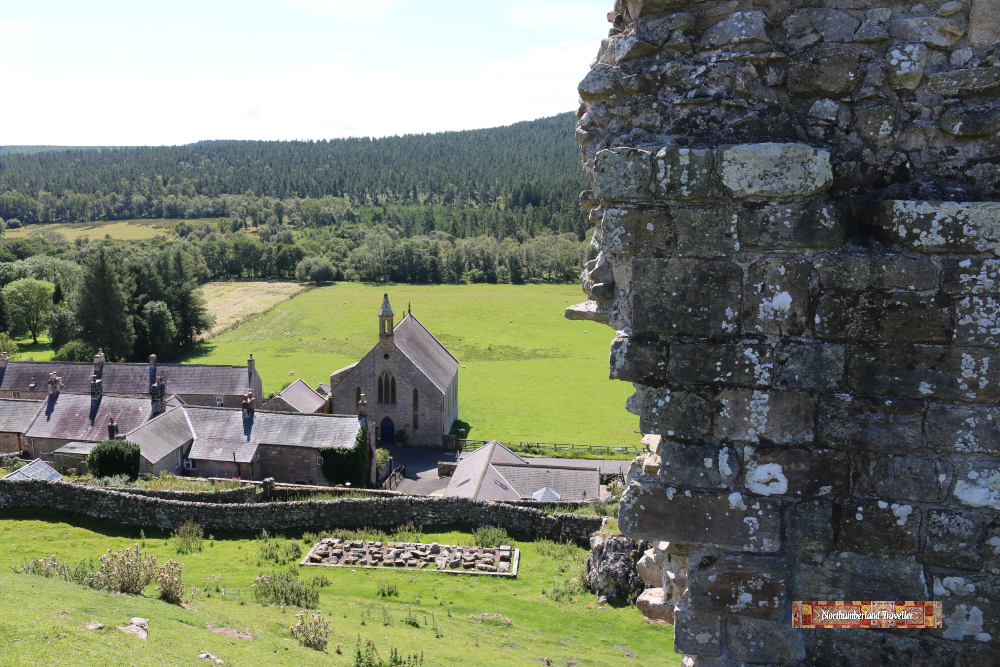
View of Harbottle village from the castle.
Harbottle Castle was built between 1157 and 1189 by Odinel de Umfraville (the Umfravilles were also behind Prudhoe Castle) on the orders of King Henry II who wanted to project his power and strengthen England’s border defences against the Scots. The Scots captured the castle for a time in 1174.
Looking at its ruined state now it is difficult to imagine it was once fit for royalty. Henry VIII’s sister, Margaret Tudor, stayed here in 1515 where she gave birth to a daughter, also called Margaret, who became grandmother of King James I of England (James VI of Scotland).
Thomas Dacre, as Warden for the area during Henry VIII’s reign, conducted his border ‘reiving’ activities from here but following the Union of the English and Scottish Crowns in 1603 the castle became redundant and fell into ruin. Many of the stone blocks were plundered for use in private dwellings nearby.
Drake Stone
The Drake Stone is the prominent stone slab which can be seen in the distance on the hilltop viewed here from the castle.
It is an easy-ish walk on a well-defined footpath through the heather moorland up to Drake Stone, also known as the Dragon’s Stone, Draak’s Stone, Draag’s Stone or Druid’s Stone. According to legend it was a meeting place of druids in ancient times.
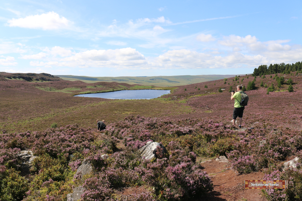
A nice view of the heather moorland looking back towards the castle.
Drake Stone is a huge, smooth sandstone boulder, about 30 feet tall, left behind by an Ice Age glacier. It is thought to be the largest boulder in Northumberland weighing over 2000 tons. It is said to have magical healing powers and up until not long ago children were passed over the stone to cure them of illness. Perhaps for this reason, author W.W. Tomlinson in his 1909 book Comprehensive Guide to the County of Northumberland was able to write “Harbottle is an exceptionally healthy place, the death rate being only 4.7 per thousand, and mortality among children almost unknown.”
Continuing south west the footpath descends to a small lake called Harbottle Lough which also has a mysterious reputation, said, according to folklore, to be under the protection of an unknown being or creature. That didn’t seem to bother one woman who was brave enough to swim in it during our visit (it was an unusually hot day).
How to Get to Harbottle Castle
The location is marked on this map:
Northumberland National Park has produced a useful online brochure detailing the route of a 5 mile, 2 1/2 hour walk encompassing Harbottle Castle, Drake Stone, West Wood and the village of Harbottle. This is their map and directions for the walk.
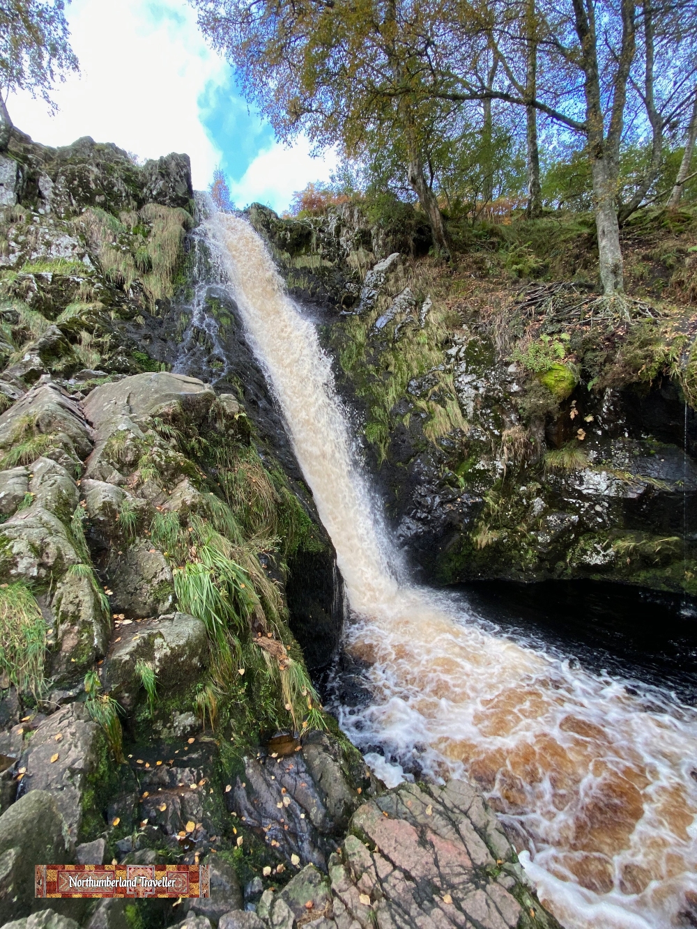
This Linhope Spout Walk is a 3 mile, mildly strenuous hike and makes an enjoyable outing if the weather is reasonable.
The highlight of the walk is Linhope Spout, a 60 foot or 18 metre waterfall in the Cheviot region in the Northumberland National Park. The chute funnels water originating from numerous grassy moorland springs into the River Breamish, which flows into the River Till before joining the River Tweed.
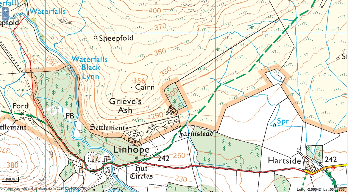
Route
I have marked the route in red. Distance 5.13km (there-and-back), Vertical gain 107m, highest point 302m, lowest point 236m.
The walk starts at Hartside Farm, part of the scenic Linhope Estate. You must park on the left side grass verge just before the farmhouse (no cars allowed beyond this point).
Walking along the road, the route passes woodland on the right before descending into the tiny hamlet of Linhope.
From Linhope a signpost directs you up a track skirting more woodland where you might be fortunate enough to spot elusive red squirrels (we didn’t, but we did see a dead mole).
Following the trail, another fingerpost directs you downhill to Linhope Spout waterfall.
Wild swimming enthusiasts are known to take a dip here and I have seen a video of people jumping into the plunge pool from the rocks above. Rather them than me! Looks very dangerous. Nobody was braving the cold water during our visit in mid-October.
After admiring the waterfalls you return to the car by the same route.
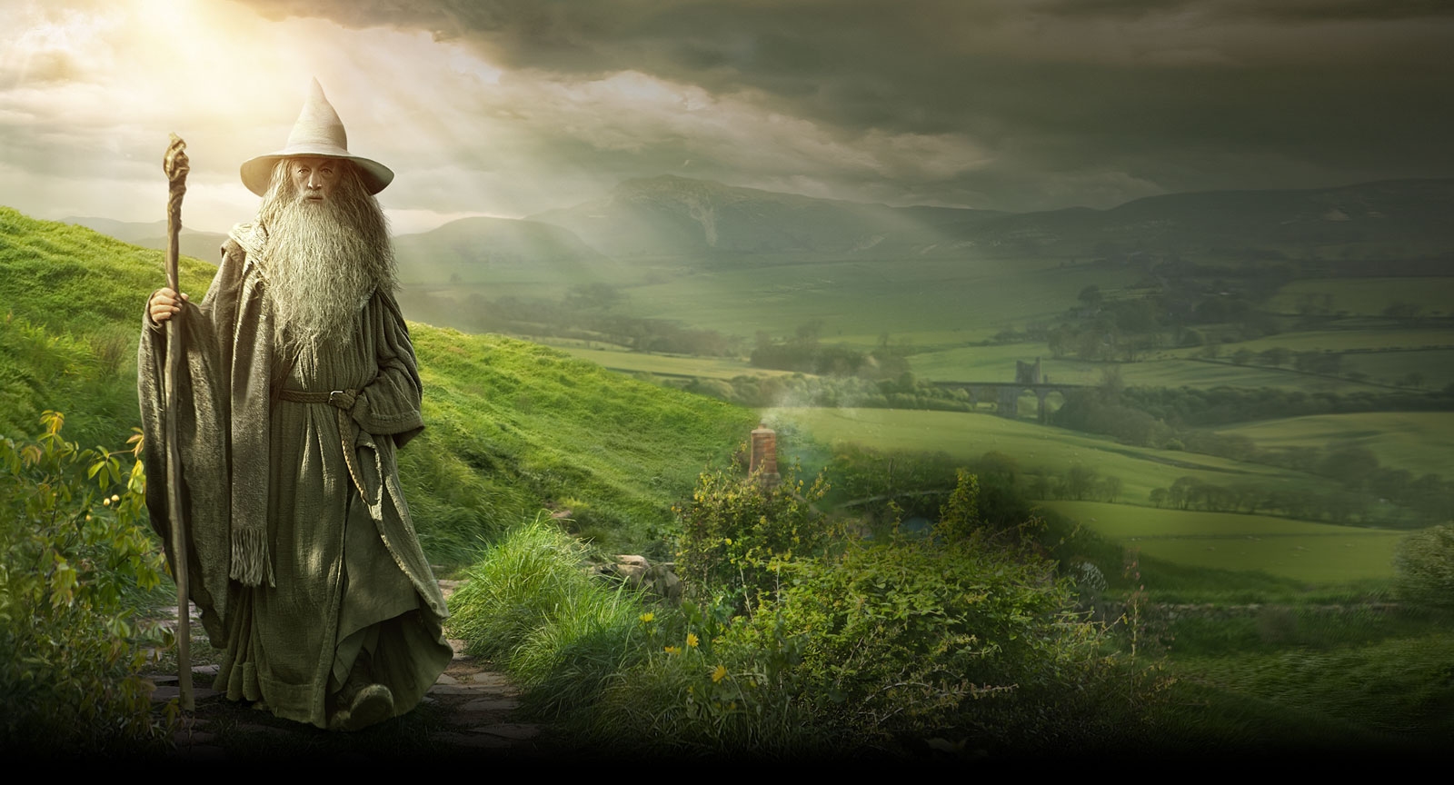
Middle Earth fans know that the Lord of the Rings and Hobbit movies were filmed in New Zealand. But the green and pleasant shire appearing in this 2012 poster for the film The Hobbit: An Unexpected Journey is not a view from the NZ Hobbiton movie set but is actually a real life location in Northumberland, England.
The poster has been enhanced with some computer-generated imagery but behind Gandalf you can clearly make out the ruined outline of Edlingham Castle and a railway viaduct of the old Wooler to Alnwick line, disused for more than half a century.
As a comparison, I took this photo recently from a layby on the B6341 just below a rocky hilltop called Corby Crags near Alnwick. You could imagine Bilbo Baggins and friends feeling at home in this tranquil countryside.
Nearby Alnwick Castle was the filming location for a number of the Hogwarts scenes in the Harry Potter films so this scenic corner of Northumberland has a lot to offer lovers of the modern fantasy genre.
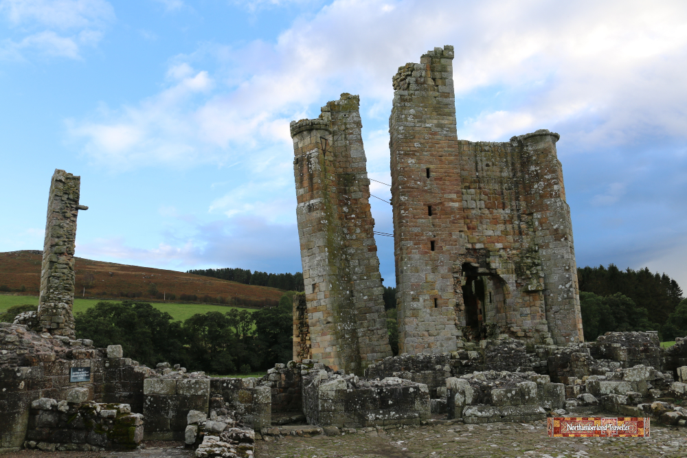
Edlingham Castle itself is well worth a closer inspection.
This stone manor house dates from around 1250 and was extended and fortified over the centuries to defend against raids by Border Reivers. The castle was abandoned in the mid 1600s and much of the stone was removed for use in other buildings.
Most of what remains is the living quarters (known as the Solar House) and the foundations of the curtain walls, the kitchen block, the gatehouse and barbican.
Next door to the castle is the medieval church of St. John the Baptist where one of the castle’s early owners, William de Felton, lies buried. The church tower was also built in the style of a fort to defend the occupants from the constant Anglo-Scottish skirmishes which plagued these borderlands from 1300-1600s.
The railway viaduct behind the castle was built in the 1880s and it is likely that much of the stone used in its construction was ‘borrowed’ from the castle.
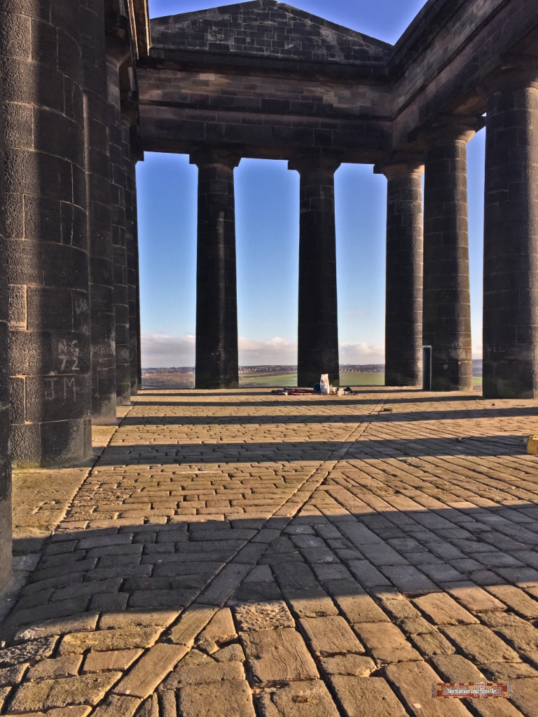
The Penshaw Monument near Sunderland was built in 1844 in memory of John Lambton, the first Earl of Durham and Governor General of Canada (1792-1840). A prominent landowner and mine owner, he was known as ‘Radical Jack’ for his support of the 1832 Reform Act which extended the right to vote to about one in five of the adult male population of England and Wales (women and poor people were still excluded, so not that Radical!). He also used his own money to support retired pitmen which boosted his popularity.
Theseum Temple in Athens
The monument is a grand folly, modelled on the 5th century BC Hephaestus Temple or Theseum in Athens, though a rather poor and scaled-down imitation of it. The money would have been better spent on his radical causes in my opinion but at least we can all enjoy the views from the monument which has been owned by the National Trust since 1939.
Situated on Penshaw Hill it can be seen from miles around. The singer Bryan Ferry grew up in this area.
A wall plaque reads:
This stone was laid by Thomas, Earl of Zetland Grand Master of the Free and Accepted Masons of England assisted by the Brethren of the Provinces of Durham and Northumberland on the 28th August 1844 being the foundation stone of a memorial to the memory of John George Earl of Durham who after representing the County of Durham for fifteen years was raised to the peerage and subsequently held the offices of Lord Privy Seal, Ambassador Extraordinary and Minister at the Court of St. Petersburg and Governor-General of Canada. He died on the 28th July 1840 in the 49th year of his age. The monument will be erected by the private subscriptions of his fellow countrymen, admirers of his distinguished talents and exemplary private virtues.
The columns are still blackened from the smoking chimneys of Sunderland’s industrial past.Hairy cattle grazing next to the monument.
The Lambton Worm
Penshaw Hill’s other claim to fame is its association with the Lambton Worm. According to the legend and Geordie folk song, Penshaw Hill was the lair of a dragon-like monster which terrorised the local villagers until it was killed by a character who was also called John Lambton. Here is an extract, if you can understand the local dialect:
This feorful worm would often feed On caalves an’ lambs an’ sheep, An’ swally little bairns alive When they laid doon te sleep. An when he’d eaten aall he cud An’ he had had he’s fill, He craaled away an’ lapped he’s tail Ten times roond Pensha Hill.
Penshaw Monument in the background, viewed from Herrington Country Park which was built on the site of a former colliery.
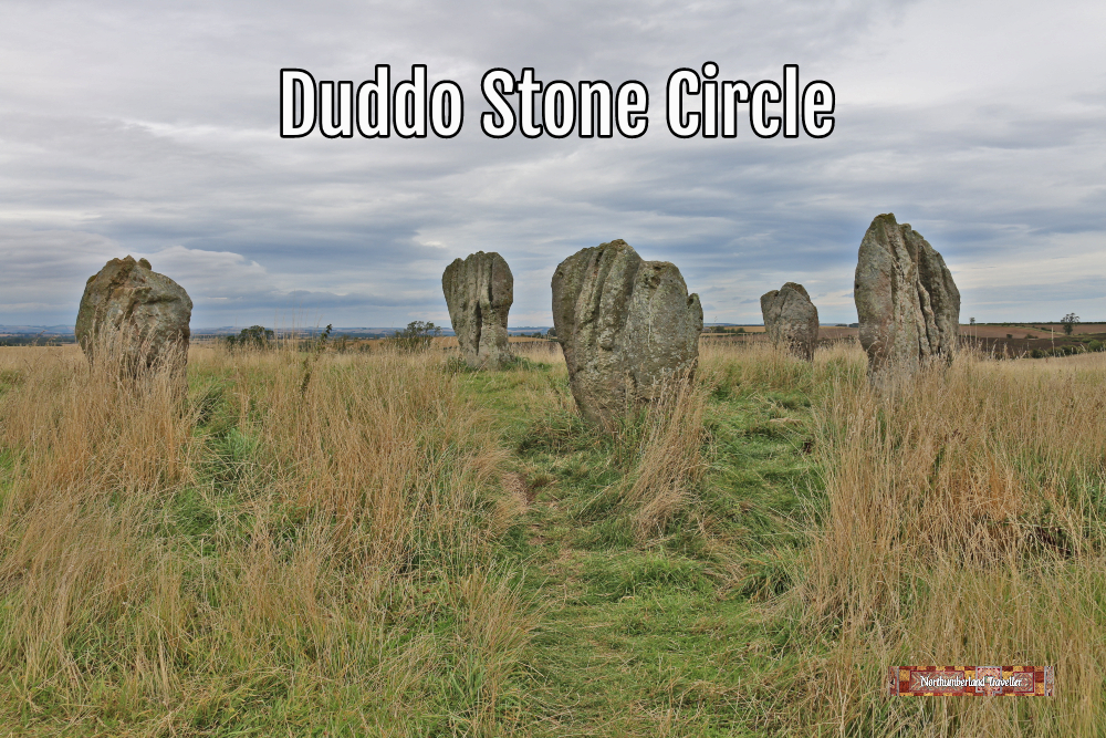
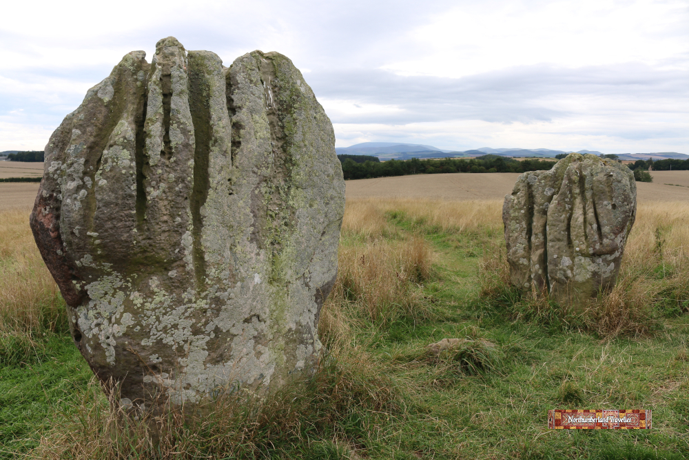
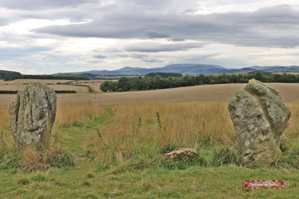
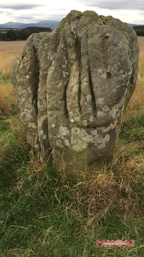
Duddo Stone Circle, also known as Duddo Five Stones, is a 4,000 year old stone circle in North Northumberland, close to the Scottish Border.
There are known to be over 1250 prehistoric stone circles littering the countryside in the British Isles. Along with standing stones, henges, dolmens and cup-marks these mysterious relics from past civilisations are enshrouded in legend and myth. Stone circles began appearing around 3000BC and they range in size from spectacular rings such as Stonehenge to this rather modest example at Duddo.
The information board at the site reads as follows:
Duddo represents an exceptionally clear example of the relationship between a stone circle and its setting. The circle visible today is incomplete. Sometime before 1852 two stones were lost from the north-west quadrant, leaving only five stones remaining. Of these, the most north-easterly stone fell sometime during the 19th century and was pulled to the north to admit ploughing across the interior of the circle. It was re-erected around 1903.
Prior to that date the circle was known as Four Stones.
Nice scenery with Cheviot Hills in the background.
Radiocarbon dating suggests that the stones were erected around 2000BC and ancient cremated human remains have been found in a pit at the centre of the circle.
On this exposed hilltop the stones have felt the effects of 4,000 years of wind and rain erosion scoring deep cuts and scars in the soft sandstone and at least one of the rocks appears to bear man-made cup-markings whose symbolism is unknown.
The stones vary in height from 1.5m to 2.3m and are arranged in a rough circle with a diameter of about 10m.
Various nicknames have been given to the stones such as ‘Singing Stones’, perhaps due to the sound made by wind passing over their surface. Also ‘The Seven Turnip Pickers’ which could be a reference to the tale that seven farm labourers were turned into stone by God as punishment for working here on the Sabbath.
From some angles they resemble clenched fists or a set of receding teeth.
How to Get to Duddo Stone Circle
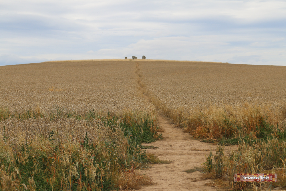
You have to walk through fields of Weetabix to reach the stones.
The location is marked on this map. There is space for a few cars on the grass verge at the point marked. Be sure not to block the farmer’s access.
The walking distance from the parking to the stone circle and back is under 1.5 miles (2.3km). Allow an hour for the round trip.
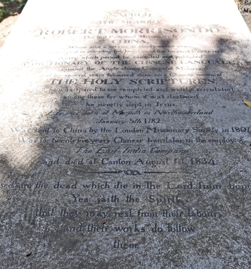
In a corner of the tranquil Protestant Cemetery in Macau lies the grave of Robert Morrison, recognised as the first Protestant missionary to China. He translated the Bible into Chinese and compiled and published an Chinese/English dictionary.
I visited the graveyard in 2015 and took this photo of his tombstone. The lighting was poor but you might just be able to make out that he was born in Morpeth in Northumberland on January 5th 1782.
Since I am familiar with Northumberland, Macau and Malacca (all places connected to Morrison) I thought I would see if I could find out more about this devout and steadfast man.
He is generally thought to have been born on a street called Bullers Green on the outskirts of Morpeth (though some say he was born in the tiny hamlet of Wingates, about 11 miles from Morpeth and moved to Bullers Green in infancy). The house at Bullers Green no longer stands but this is the location:
The inscription above the archway reads Victoria Jubilee Year. This house replaced the one in which Robert Morrison D.D. was born. (DD means doctor of divinity).
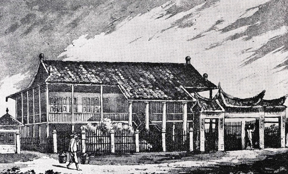
When he was three the family moved to Newcastle-upon-Tyne where his father established himself as a last and boot maker in Groat Market which might have looked like this at the time. The street has far less character today.
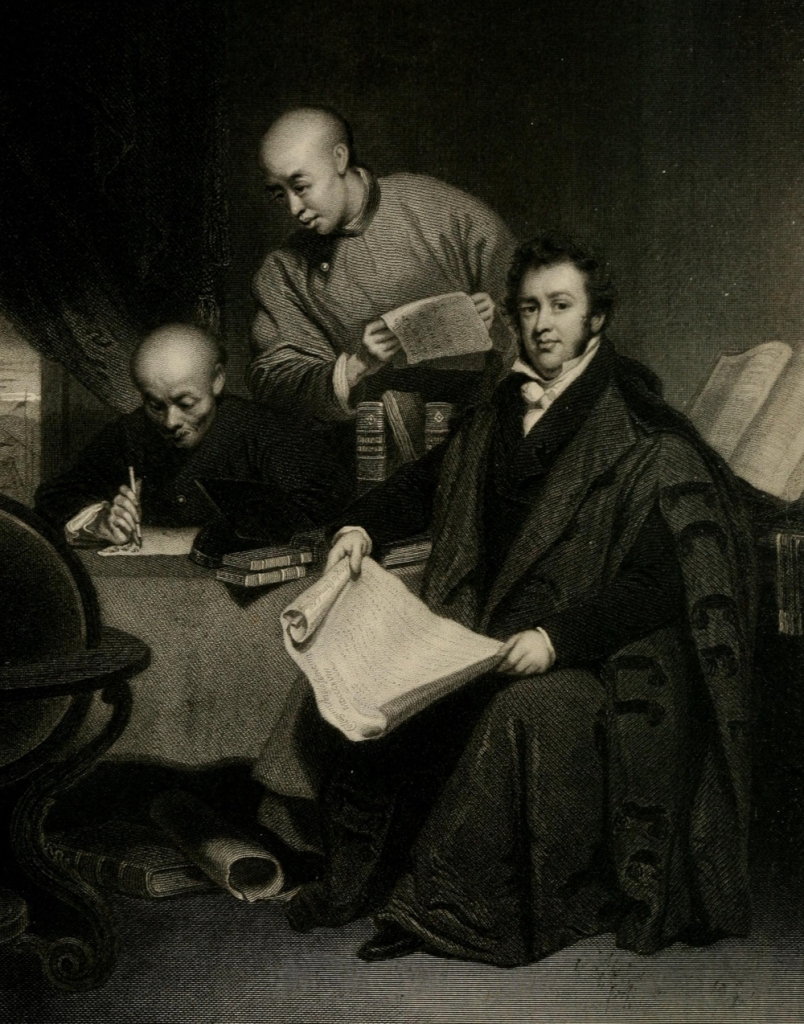
Dr Morrison translating the Bible into Chinese from the painting by George Chinnery.
Robert, the youngest of eight children was a serious and hard working boy and had a strict religious upbringing by his Presbyterian parents. At age 14 he left school and trained as an apprentice in his father’s cobbler business. As a teenager he went slightly off the rails, falling into bad company and, like many a Newcastle lad, was prone to excessive drinking on occasion. However, after having the fear of eternal damnation drummed into him by his pastor he reformed his ways, and eventually passed his examinations as a clergyman and applied to the London Missionary Society to serve abroad. He learned some Chinese in London and was selected to start a mission to China. Although his wish was convert ‘poor perishing heathens’ the objectives set were more practical; to compile a Chinese dictionary and translate the New Testament into Chinese. Any conversions he achieved along the way would be a bonus.
Another version of the same painting. Which one was the truer likeness I wonder?
It was no easy task and he was not made welcome. For a start Christian missionaries were banned in China, on pain of death for the preacher and the converts. That is why he only converted ten Chinese over a period of 27 years. Secondly Chinese were forbidden to teach their language to foreigners and anyone who has tried studying Chinese knows that it is one of the hardest languages in the world to master. Thirdly, the Roman Catholic priests in Macau did not want Protestant clergymen in their territory and pressed the Portuguese authorities to expel him. The East India Company, which controlled most of the British trade in Macau and Canton, did not allow missionaries to travel on their ships so Morrison was forced to arrive on an American ship disguised as an American. And the British and other foreign traders did not welcome criticism from a Bible-bashing Brit since they were nearly all involved, directly or indirectly, in the opium trade. Morrison described many of his countrymen as riff-raff, unjust, covetous, avaricious, lying, drunken and debauched. They in return regarded him as irritating, narrow-minded, scornful and completely humourless.
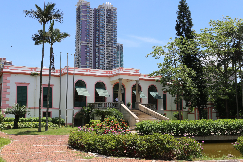
The Casa Garden, the former Macau residence of the East India Company’s senior supercargo. The Protestant Cemetery is adjacent to the house.
Somewhat ostracised he was left in lonely isolation he was able to devote himself to his dictionary and, only when this had been published and he had become fluent in Chinese, did he become useful to the East India Company who employed him as a translator. He married Mary Morton in 1809, the daughter of an East India Company surgeon, and they kept each other company in their seclusion. They had two surviving children but she died of cholera in 1821 and, since Morrison would not have his wife buried in a Catholic cemetery, the Protestant cemetery was established in Macau. He later remarried and had a further five children.
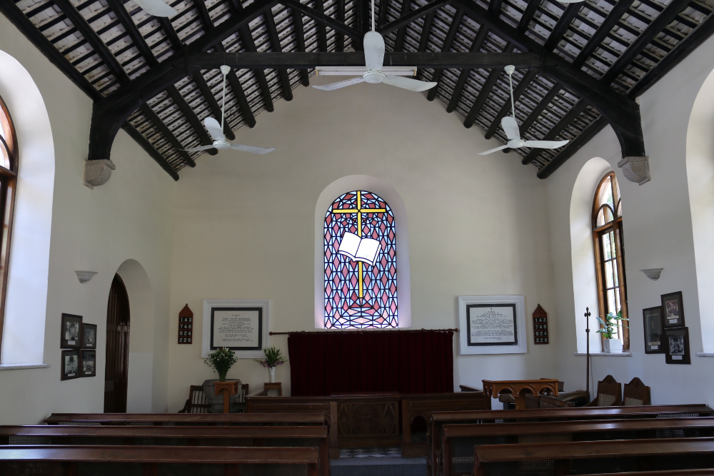
Morrison Protestant Chapel in Camōes Square, Macau (next to the cemetery).
Morrison died in Canton on 1 August 1834 and his body was brought to Macau and buried next to his first wife and child. By the time of his death the entire foreign community in Canton and Macau had come to admire his character, even if they didn’t much like him. A fellow missionary, an American Sinologist called Samuel Wells Williams, summed Morrison up as ‘not by nature calculated to win and interest the skeptical or the fastidious, for he had no sprightliness or pleasantry, no versatility or wide acquaintance with letters, and was respected rather than loved by those who cared little for the things nearest his heart’.
The Anglo-Chinese College in Malacca
Morrison’s name is also associated with Malacca (in Malaysia). Another missionary, William Milne, was sent out to assist Morrison, arriving in Macau in 1813 but he was not permitted to stay. After some time in Canton, he moved on to Malacca where, under Morrison’s guidance, he established a school called the Anglo-Chinese College in 1818. After Hong Kong became a British territory the school relocated there in 1843 under the name Ying Wa College. It is still going today. Milne died in Malacca and he is commemorated in Christ Church, Malacca.
Last month I walked north along the coastal path from Berwick-upon-Tweed up as far as the Scottish Border. On Google Maps it is marked as the Northernmost Point of England.
It would be an easy mistake to think that the northernmost point of England is the same location as the southernmost point of Scotland but that honour goes to Mull of Galloway in Drummore about 130 miles to the south-west as the crow flies.
Fishermans Haven Beach, Berwick-upon-Tweed
The clifftop walk from Berwick to the border is a distance of around 3.5 miles each way. My route started near Fishermans Haven Beach and skirted a golf course on the fringes of town.
The underwater pipe is probably a sewage outlet. I hope it has been treated first.
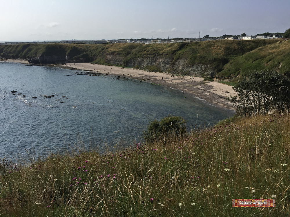
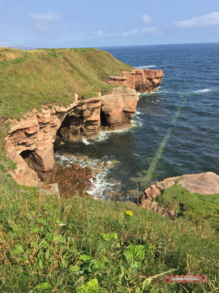
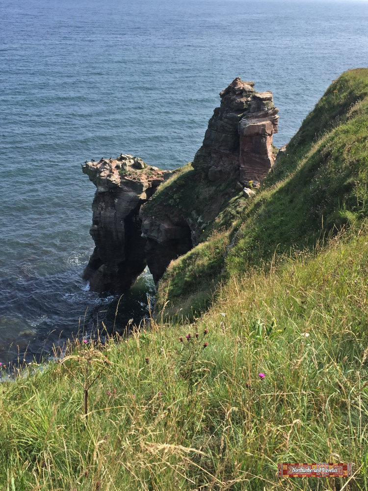
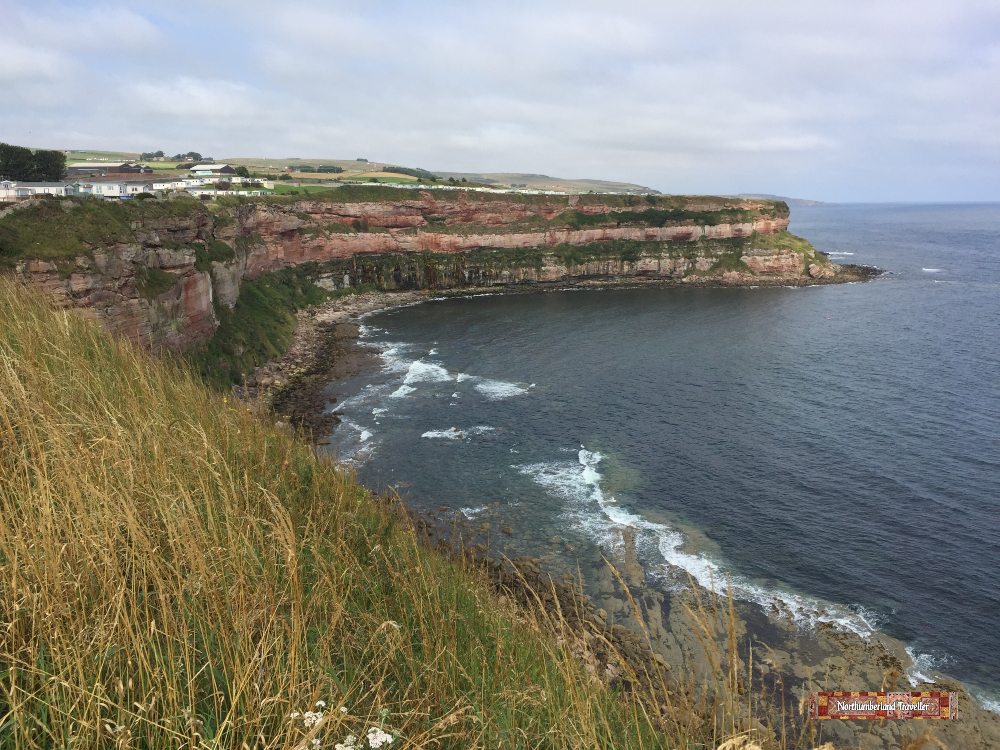
The Northumberland coastline is quite spectacular here with dramatic cliffs, isolated coves and clear seas.
Seagulls and other seabirds take advantage of the rugged coastline to nest among inaccessible ledges and crevices.
There are a lot of holiday parks perched on the clifftops in this area. This one is at Marshall Meadows Bay.
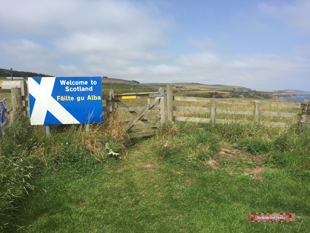
The border is marked with a welcoming sign. Let’s hope this does not become a hard border if Scotland ever achieves independence.
The sign on the other side informs us that ‘the English / Scottish border dates back to 1237 at this point when it was established under the Treaty of York. There were many subsequent disputes but in 1482 Berwick was taken by England and the Border fixed at this point. In July 1503 Margaret Tudor, the daughter of King Henry VII of England, met the representatives of King James IV of Scotland in Lamberton, thus leading to the eventual succession of James VI to the English throne. Tradition has it that she landed on the shore at a place called Meg’s Dub.’
Meg’s Dub and Lamberton are a short distance from here.
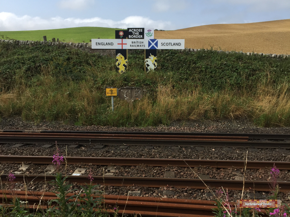
The main London to Edinburgh railway line runs close to the coast at this point and passengers might catch a fleeting glimpse of this sign from their train windows. Funny how the field changes colour from green to brown at the border.
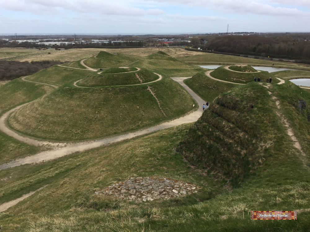
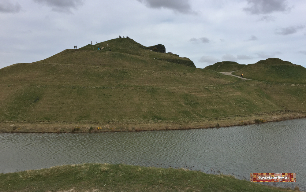
Northumberlandia is a country park with a unique landscape sculpture in the shape of a giant reclining woman It is said to be the world’s largest human landform sculpture and is best appreciated from above. Drones are not permitted so the best place to pick out the shape of this lady is from the viewpoint located on her forehead. Other viewing mounds are found on her chest, hands, hip, knee and ankle. She has been dubbed the Lady of the North and can be considered as a companion to the Northeast’s more famous sculpture, the Angel of the North at Gateshead.
Northumberlandia was designed in 2004 by American architect and artist Charles Jencks (1939-2019) who drew inspiration from Northumberland’s Cheviot Hills. Built on the site of a former surface coal mine, this project shifted 1.5 million tonnes of rock and soil to conceal the scars left over by mining and create this new 46 acre park with three lakes, moderate slopes, four miles of paths and a woodland trail.
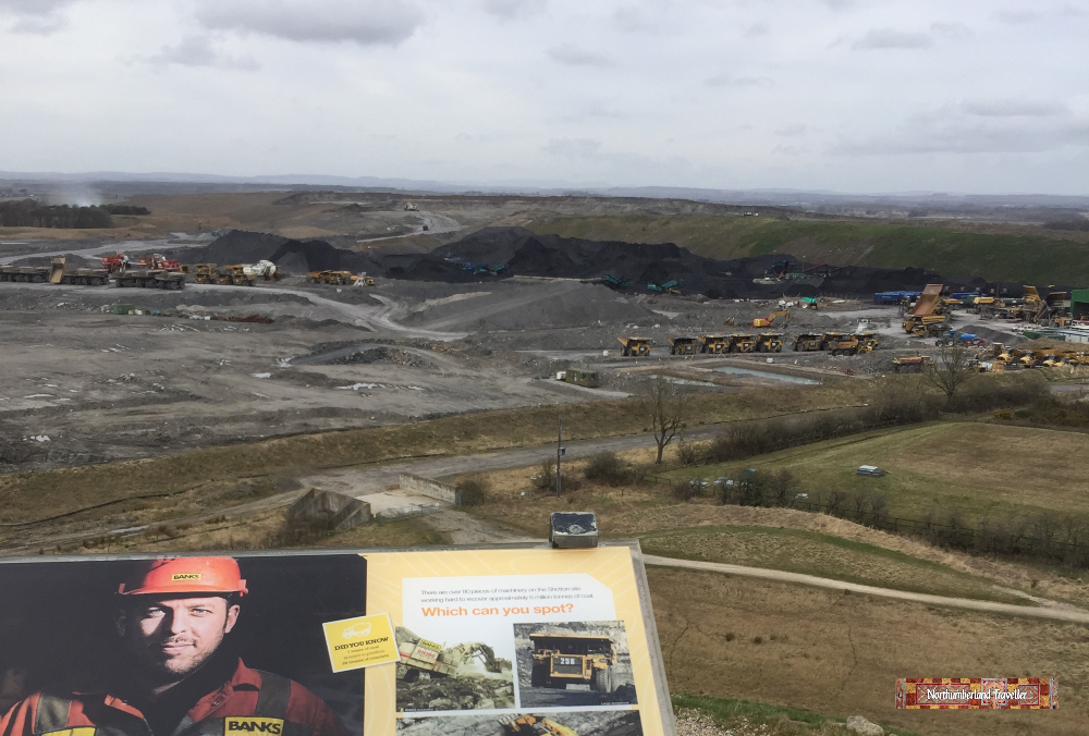
From the viewpoint visitors can overlook Shotton Surface Mine which once extended over the site now occupied by Northumberlandia. The coal mining company, Banks Group, has put up an information board to explain how the site will be restored and regenerated once all the coal has been mined, including a promise to plant 88,000 trees. Perhaps they should make a male version of the Lady of the North to keep her company.
Viewed from her forehead, this photo shows her left eye and nose, her … umm … boobies, a hip and a knee. This is still a fairly recent construction and the landscape will be left to evolve and mature over time.
These photos were taken on a chilly day in March, just before the Covid-19 lockdown. It has now reopened to the public.
Opening Times & Admission Charges
Open Daily from dawn to dusk.
The visitor centre, café and toilets are open from Thursday to Sunday from 10am-4pm.
Ticket Prices
Entrance is free.
Car Park
There is plenty of free parking but a donation of £2 is suggested to cover maintenance costs.
How To Get to Northumberlandia
The location of Northumberlandia can be found on this map:
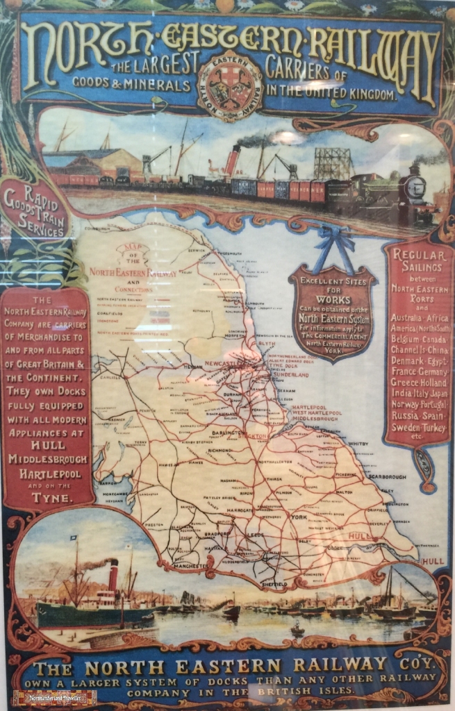
Wylam Railway Museum was opened in 1981 coinciding with the bicentenary of the birth of Wylam’s most famous son George Stephenson (1781-1848), known as the Father of Railways.
This tiny museum is housed in a former classroom of the old Wylam Primary School. It shares the building with the village library.
The museum may be small but it is packed with interesting railway artefacts and exhibits.
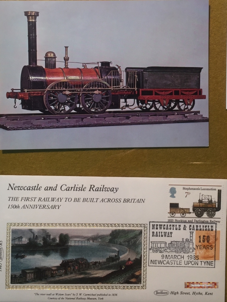
There is a wall chart displaying obscure trivia about the history of the Newcastle and Carlisle Railway, the first railway to be built across Britain . For example you may not have heard of station clerk Thomas Edmondson who invented a system of cardboard tickets which became the standard used around the world.
Then there was the Sabbatarian Reverend W C Burns who authored this poster threatening eternal damnation to anyone who took a train trip on a Sunday. Perhaps he foresaw that most of his hard working parishioners would sooner spend their one day off per week quaffing ale in a pub in the North Pennines rather than listen to his dreary sermons.
Exhibits focus on the contribution of local railway pioneers such as George Stephenson, William Hedley, Timothy Hackworth and Nicholas Wood.
There are models of Wylam Station, North Wylam Station and Wylam Railway Bridge.
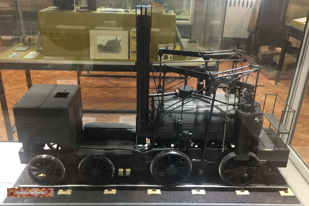
Puffing Billy
There are also large scale models of two famous locomotives, Puffing Billy and Wylam Dilly, which were in use at Wylam Colliery to haul coal wagons in the early 1800s.
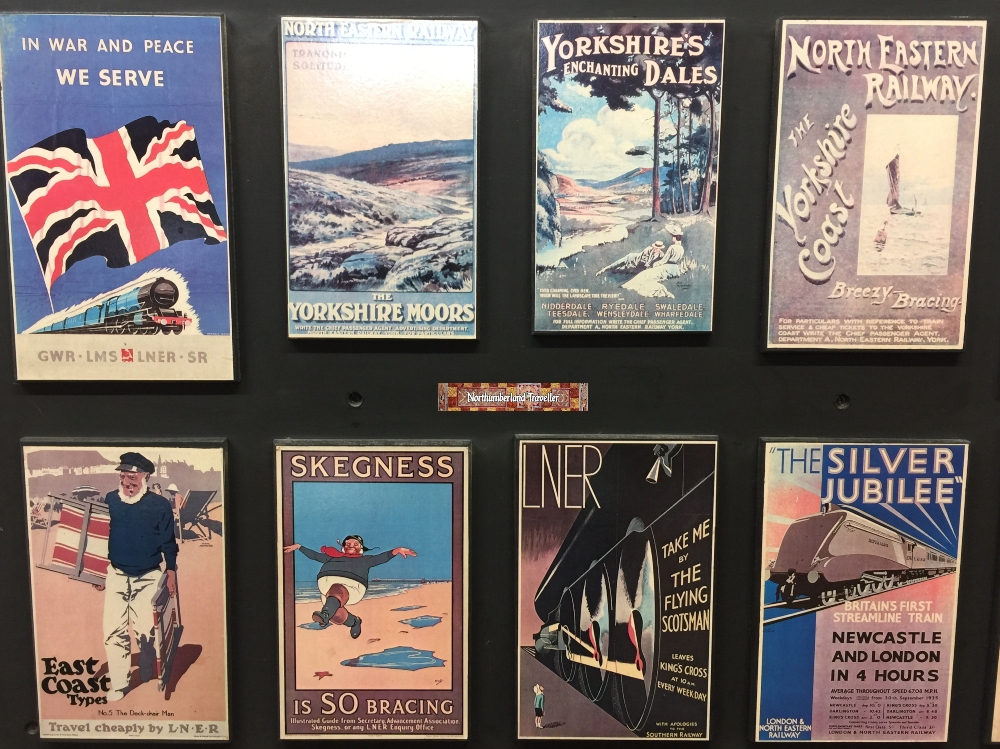
There are a lot of old photographs, maps and vintage railway posters on display.
Opening Times & Admission Charges
The museum is open during library opening hours:
Tuesday 1 – 6 pm Thursday 1 – 6 pm Saturday 9 am to 12 noon
Ticket Prices
Entrance is free.
How To Get to Wylam Railway Museum
The location of the museum can be found on this map:
Address:
Wylam Railway Museum The Falcon Centre Falcon Terrace Wylam NE41 8EE
GPS:
54°58’37.2″N 1°49’04.1″W 54.977003, -1.817793
Plus Code: X5GJ+RV Wylam
Tel: Wylam Parish Council 01661 852498 Wylam Library 01661 852174
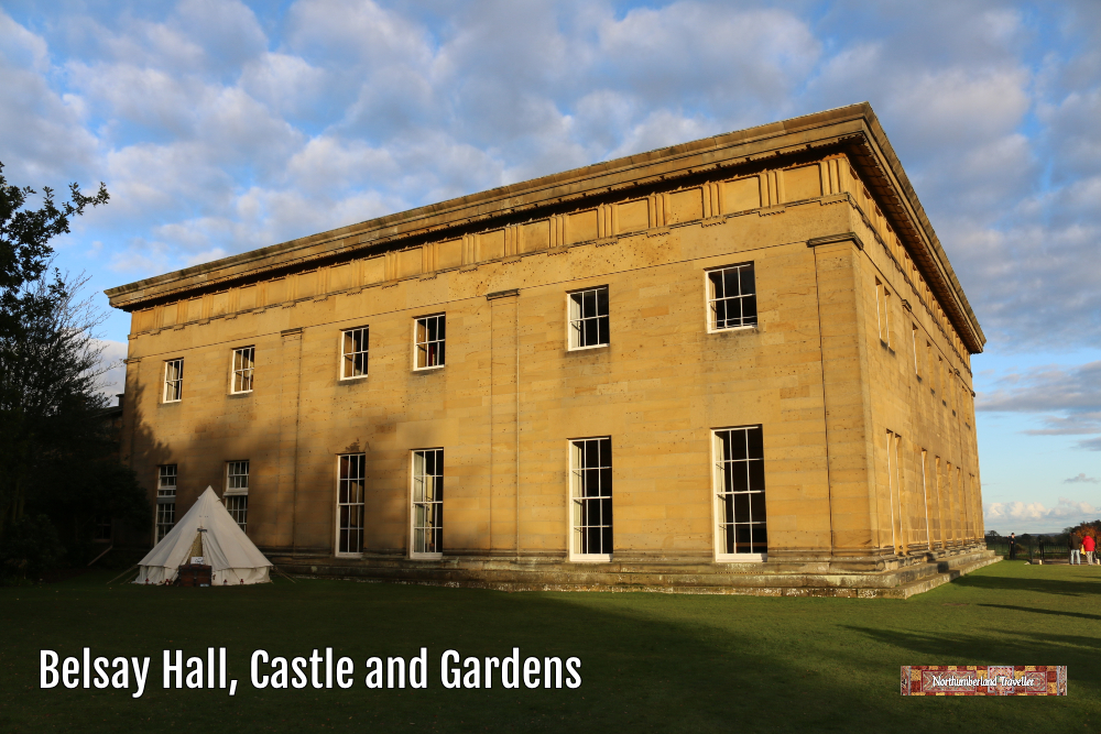
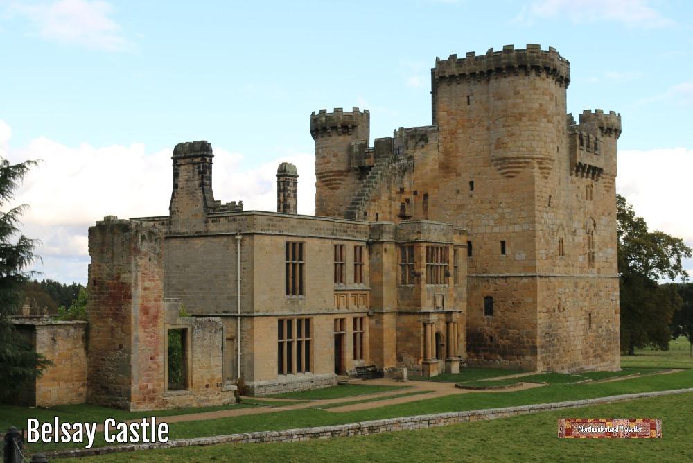
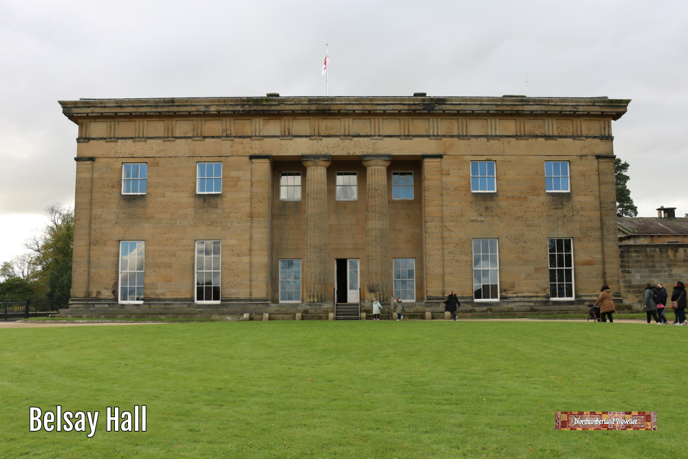
Belsay Hall is one of Northumberland’s top tourist attractions comprising a medieval castle, a stately home and picturesque gardens linking the two.
The Belsay Estate was home to the Middleton family (not related to Kate Middleton) for 700 years from 1270 when Sir Richard Middleton was Lord Chancellor to King Henry II. The hall, castle and gardens were taken into the guardianship of the state in 1980 and are now managed by English Heritage.
The impressive fortified pele tower of Belsay Castle was built in the late 14th century to defend the occupants against frequent raids and unrest in this border region of England. After the conflict between Scotland and England died down the Middletons converted the castle into a more comfortable home by adding the elegant country house extension that we see here (now without a roof) which was built from 1603-1614.
The family abandoned the castle in 1817 and moved into the nearby newly-built Belsay Hall whose Greek Revival architectural style was inspired by the owner’s honeymoon trip to Greece. This owner, Sir Charles Monck, was also a Middleton but changed his name in order to inherit the substantial estates of his wealthy maternal grandfather.
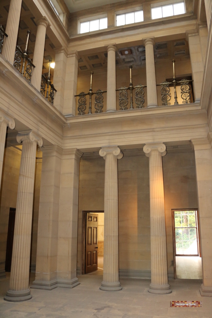
Today the Hall is empty of furniture, which is a shame but it does enable visitors to appreciate the beauty of the Roman/Greek architecture. During our visit one room was being used for a ‘multi-sensory installation’ featuring words and music by Estonian composer Arvo Pärt.
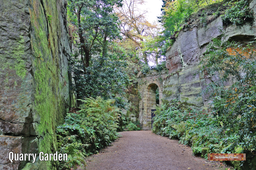
The Castle and Hall sit in 30 acres of grounds. Sir Charles made use of the excavations left behind when the stone for the hall was cut to create a quarry garden. With its sheer-sided canyon walls it has its own micro-climate out of the wind enabling exotic trees and rare plants to survive (although when we visited last October it was freezing)! There is also a Rhododendron Garden, which comes into flower in spring, and more formal gardens around the Hall.
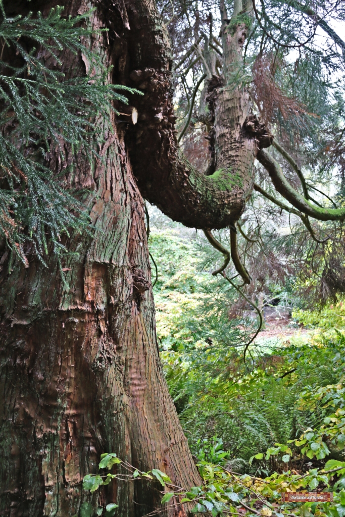
For me, the majestic Yew trees and other conifers and hardwoods were the stars of the gardens.
The former stable block houses the tea room, shop, ticket office, toilets etc.
You can find details of opening hours and prices on their English Heritage’s website (indoor spaces are currently closed due to Covid restrictions).
How To Get to Belsay Hall
The hall is located about 15 miles north-west of Newcastle Upon Tyne.