It has been a while since I climbed any hills in Malaysia.
Bukit Sapu Tangan is a baby hill, only 200m or so high, but it provides a good work-out in the sweaty tropical conditions. It is located in Taman Botani Negara Shah Alam (formerly known as Malaysia Agriculture Park).
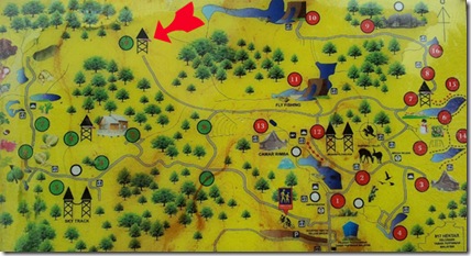
The red arrow marks the location of Bukit Sapu Tangan, about 6km round trip from the entrance gate of Taman Botani Negara Shah Alam.
I went there yesterday, a public holiday in Malaysia, to take advantage of the light traffic conditions. Taman Botani is a huge park on the outskirts of KL which once formed part of a vast unspoilt forest but is now hemmed in on all sides by the capital’s fast expanding urban sprawl. See this Google Map (link below) to get an idea of how encroaching development is nibbling away at the edges of the park.
https://www.google.com.my/maps/@3.1083453,101.5050332,6757m/data=!3m1!1e3
Once inside the park you soon forget about the bustle of the city as the sounds, sights and smells of the jungle take over. Being a public holiday, the main trails within the park were busy, particularly with cyclists as bikes can be hired inside the park. The terrain is quite hilly and unless you are super fit and have a bike with good gears, you end up pushing your bike uphill for much of the way. (Mums and Dads should avoid renting their own bikes as they will spend most of the time pushing their children along).
The path to Bukit Sapu Tangan is marked with a sign showing a distance of 1.8km. This distance, and the fact that the path becomes narrower and steeper, is enough to put off most visitors and I saw nobody else hiking on this section. But it is still a tarmac path so easy to walk on and no need to worry about snakes and other creepy crawlies. Apart from a few skink lizards, small birds and the sound of monkeys crashing around in the treetops, I did not come across much wildlife.
At the top of the hill is a concrete and wood view tower from which there was a somewhat hazy view of Shah Alam city centre and beyond.
The view from this side gives an idea of the scale of the park but to the rear more new housing developments are underway, threatening the fragile eco-system of this once pristine forest.
Bukit Sapu Tangan translates as Handkerchief Hill. Perhaps its odd name means that you have to take some sort of cloth with you to mop your brow. Or perhaps it refers to the future size of the park once all the planned development projects are finished!
You can find more details about Taman Botani (Malaysia Agriculture Park) on my Malaysia-Traveller website.


