High Road Across Malaysia – Conclusion

IMG_6157

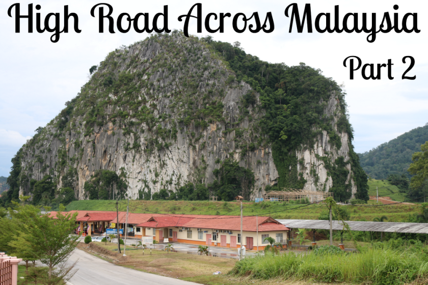
This post records the final section of my coast to coast journey across Malaysia via Cameron Highlands, Gua Musang & Lake Kenyir.

IMG_6156

After a Thrifty Traveller breakfast of roti canai and kopi kosong for just RM2, I left Gua Musang for the nearby village of Pulai.

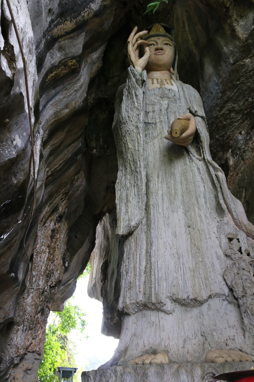
Kampung Pulai is famed for its Guan Yin temple, known as the Water and Moon Temple, thought to be over 400 years old, making it perhaps the oldest in Malaysia. Hakka Chinese settled here more than 600 years ago in search of gold and they maintained their traditional Hakka culture, largely undisturbed by the outside world until the first tarmac road to the village was built in 1988.

The village has a lovely setting, alongside a small river and a lake, surrounded by rubber plantations and overlooked by spectacular limestone hills. On the opposite side of the lake, facing the village is one such outcrop called Princess Hill which contains a cave with a Guan Yin statue. To reach the cave I crossed the suspension bridge over the river and walked around the lake.

The rubber trees appeared to be well looked after with tapping still going on. There was a large buzzing hive of wild bees on one of the trees which I was careful not to disturb.

I arrived just as the elderly caretaker was unlocking the steps up to the cave.

From the top of the steps there was a good view looking back over the village in the early morning mist.

Inside the cave were a couple of large stalagmite formations, one of which has been transformed into a Guan Yin statue.

IMG_6191

After this slight detour I returned to my trans Malaysia route, leaving Gua Musang on the Central Spine Road (highway 8) for some distance before turning onto Jalan Felda Aring (1744), a minor road serving the Federal Land Development Authority (FELDA) plantations and settlements in this part of Kelantan. This was the section of the journey that I was most worried about because I was unsure what condition the road would be in and whether it would be passable. It would have been a long way back if I had to turn around. In the end my concerns were unwarranted because it was in excellent condition and with very light traffic it was a pleasure to drive.

Throughout this trip I encountered a lot of logging lorries, far more than I remember seeing on previous travels. There are newspaper reports of rampant illegal logging going on in parts of Malaysia. I don’t know where these particular trucks obtained their logs. Most of the surrounding area looked like it was deforested some time ago to make way for palm oil plantations.

IMG_6009IMG_6010

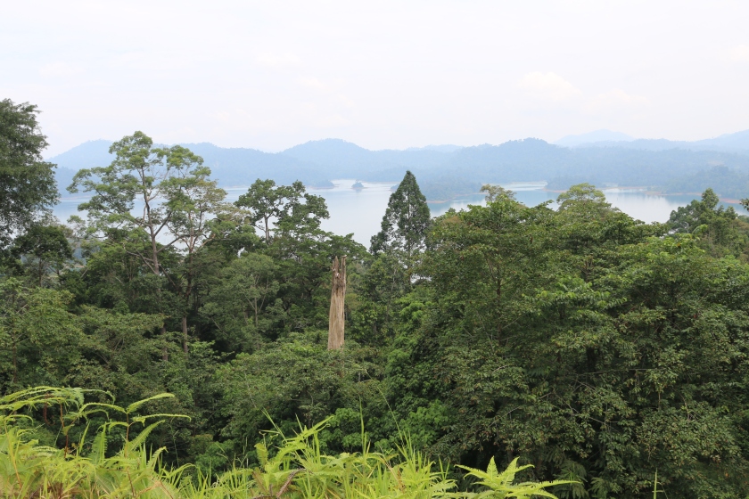
Crossing over from Kelantan into Terengganu brought more lush vegetation as I approached Lake Kenyir. This massive man-made lake was created between 1978 and 1985 by damming the Kenyir River. It is the largest artificial lake in Malaysia with an area of 260,000 hectares. 

IMG_6012

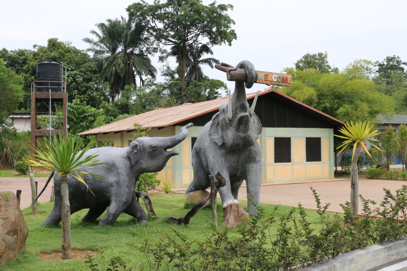
A new attraction near Lake Kenyir is the Kenyir Elephant Conservation Village. I didn’t go in but I gather it is somewhat similar to Kuala Gandah Elephant Sanctuary.

IMG_6015

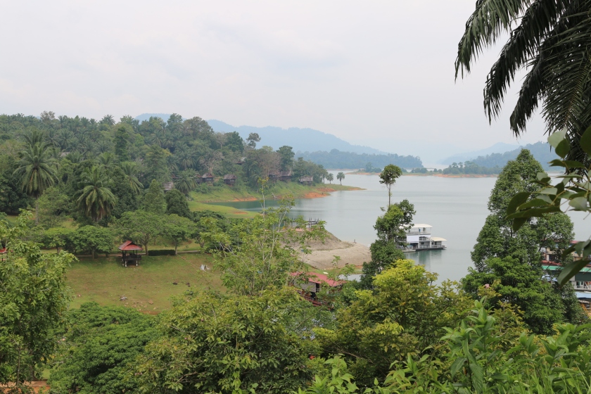
At the lakeside itself, activities include the Kenyir Water Park, boating and fishing. They have some rather ugly houseboats for rent here but I feel Malaysia Tourism could do a lot more to bring in tourists. Some Kerala style houseboats for example would be a good addition. The Lake Kenyir Resort Hotel was closed for renovation.

OLYMPUS DIGITAL CAMERA
Penarik Beach – A nice place to relax after a long drive.

From Lake Kenyir, the East Coast of Malaysia is within easy striking distance. I would have chosen to end my coast to coast journey at Penarik which has one of best stretches of beach in the area. In the end I didn’t go to Penarik this time but continued my travels up to Kota Bharu as I had other places to visit which I’ll write about in future posts.

High Road Across Malaysia – Part 2

IMG_6145b

In this post I continue my coast to coast journey across Malaysia via Cameron Highlands, Gua Musang & Lake Kenyir. See Part 1 for the map.

After a 6am breakfast at Kampar I set out for the Cameron Highlands via the old Tapah road (Route 59).

First stop was a quick look around the Kuala Woh Recreational Forest. It is tucked away in a hidden valley at the foot of the Titiwangsa mountain range. The early morning air was refreshingly cool but the camping, chalet and toilet facilities looked rather run down and there were too many mosquitos around. The river looked clean enough and the whole place smelt of tasty durians since August is the peak season for this pungent fruit.

IMG_5953IMG_5957

Next stop was Lata Iskandar, one of Malaysia’s most accessible waterfalls being located right next the busy road. This place can get busy at weekends and holidays but since it was still early I had it to myself. I climbed the steps to get a good view of the upper cascade. Everywhere was clean with no litter so somebody had been doing a good job.

IMG_5963

From here up until the Cameron Highlands there were numerous roadside stalls selling handicraft items, fresh fruit and vegetables. Most of the vendors appeared to be from the Orang Asli community.

IMG_5965
Ringlet, Cameron Highlands

Where Perak borders Pahang the Cameron Highlands begins with the town of Ringlet, probably the least developed of the three Cameron Highlands settlements (Ringlet, Tanah Rata and Brinchang) at an altitude of around 1100 metres above sea level. My car thermometer displayed a very comfortable reading of 20°C, which is about the average daytime temperature for this high altitude district, cooling to a chilly 14°C at night.

IMG_5968
The Lakehouse Cameron Highlands. Hotel, Restaurant, Bar & Spa

It has been a few years since I’ve been to the Cameron Highlands. The towns themselves have not changed much. For some years they have been rather ugly, sprawling places with too much traffic. Anyone expecting a quaint colonial hill station would be disappointed although there are still some nice parts such as The Lakehouse  Hotel and the manicured tea estates. What has changed in recent years however is the explosion of land clearance for agricultural purposes, some of it illegal, which has resulted in vast swathes of the Highlands being covered in polytunnels (see this close up satellite view as an example).

Screen Shot 2016-08-27 at 6.58.17 PM
The Cameron Highlands are covered with plastic greenhouses and shade netting to protect fruits and vegetables from the elements and insects.

While it is generally a good thing that Malaysia should grow more of its own flowers, vegetables and fruit, the forest clearing and hillside levelling has been done in an uncontrolled way resulting in serious flooding and landslide problems in recent years.

While in Brinchang I took the opportunity to visit the Time Tunnel, an interesting museum crammed with photographs, memorabilia collections and artefacts from days gone by.

IMG_6001
Beware of the tapirs. An endangered species, the chances of meeting a tapir in the wild are close to zero.

At Blue Valley I turned onto the Gua Musang road (185) and soon found myself in Kelantan state. ‘Polytunnel-land’ continued for several more kilometres before finally turning into a more natural landscape as the road began its slow descent from the uplands. It was a good road, partly dual carriageway and elsewhere with frequent overtaking lanes, not that they were needed as there was hardly any traffic. A great road for trying out your new motorbike.

The town of Gua Musang is the administrative hub for the district of the same name which covers a large chunk of southern Kelantan. Until the Central Spine Road (Federal Route 8) was built, Gua Musang was a very isolated place and could only be reached via the Jungle Railway.

During the Emergency, its isolation made it a target for the Communist bandits who attacked the township with a 300 strong force and seized control on 17th July 1948, killing one policeman and capturing another 15. Their aim was to establish a liberated zone from which to extend their grip on the country. A relief force of army and police, supported by the RAF, successfully recaptured the town five days later.

Pontianak-Gua-Musang-Ad

Gua Musang means Cave of the Civet Cats (or foxes). The limestone hills here are honeycombed with holes and the main cave behind the old railway station was believed to be home to a pack of mysterious civet cats, spawning various ghostly legends such as that portrayed in the 1960s comedy thriller film Pontianak Gua Musang.

IMG_6155
Being one of Malaysia’s more conservative states, alcohol is not so readily available in much of Kelantan. This traditional Chinese liquor shop in Gua Musang however had a surprisingly wide selection of spirits and potions.

I stayed overnight in Gua Musang at MyHome Hotel which was perfectly adequate apart from having no window. You can’t expect too much for RM 70 per night. On my receipt I noticed they had written my address as British Indian Ocean Territory. That should confuse Tourism Malaysia’s visitor statistics if they monitor such things.

I’ll continue Part 3 of my High Road Across Malaysia journey in the next blog post.

High Road Across Malaysia – Coast to Coast via Cameron Highlands, Gua Musang & Lake Kenyir

IMG_6007b

The usual way of crossing from the West Coast of Peninsular Malaysia to the East Coast, at least for people in the Klang Valley area, is via the East Coast Expressway from KL to Kuantan. It’s an excellent road with some nice scenery and the 250 km journey can be completed in about 3.5 hours.

I wanted to try an alternative route, much longer and slower and hopefully even more scenic via the Cameron Highlands and Gua Musang and from there on minor roads though palm oil plantations as far as Lake Kenyir in Terengganu. Here is a map:

Google Maps calculates the distance as 502km and the travelling time as 8.5 hours though I would not recommend attempting it all in one day. I lingered 3 days on the trip.

I started my trans-Malaysia crossing at Kampung Pasir Panjang Laut, a small village near Sitiawan, Perak on the shores of the Straits of Malacca.

This was the western-most point of the route, a small patch of unhealthy mangrove forest in front of an interesting Chinese temple called Tua Pek Gong.

One of its main attractions of Tua Pek Gong temple was a bendy tunnel in the shape of a dragon which I entered through its mouth and emerged from its tail. The interior walls of dragon were lined with murals depicting the Ten Chambers of Hell and illustrated in gory detail the gruesome tortures which await those who do not live a moral and respectable life in this world. Enlarge the bottom right photo above for an example.

Having seen enough, I drove inland on Highway 5 through Sitiawan and Ayer Tawar.  My route road crossed the Perak River near Bota Kanan where I visited the Conservation Centre for River Terrapins.

There were some sizeable mature terrapins in a couple of the holding ponds but they were fairly shy and only popped their heads above water to take bites from floating cabbage leaves.

Continuing on Route A15, I passed a sign for Tanjung Tualang Tin Dredge. I visited this place five years ago (and blogged about it) but decided to drop in again because I had read somewhere that it is now possible to go inside this giant relic from Malaysia’s tin-mining era. Sadly that was not the case. Renovation work was still ongoing and visitors were only allowed to view the exterior for the time being.

IMG_5865
Weaver birds’ nests at Tanjung Tualang.

Next stop was the small town of Malim Nawar. A quirky tourist attraction here was a brick chimney built by the Japanese during WWII for the manufacture of carbide, which is presumably the black charcoal like stuff shown below.

Next stop, still in Perak, was the town of Kampar, once a centre of tin-mining as evidenced by the large number of lakes left over from mining activity which can be seen in this Google Maps image.

Screen Shot 2016-08-22 at 7.21.35 PM
Google Map showing the lakes and ponds near the town of Kampar which were the result of tin mining.

Nowadays Kampar is thriving as a university town with the campus of University Tunku Abdul Rahman located here with other universities nearby. Here are some photos of the Kampar, mostly the old part of town.

Military historians will know that Kampar was the site of a significant battle during WWII and one of the few Allied successes in the whole Malayan Campaign. Most of the fighting took place on a series of ridges on the edge of town near the Chinese Cemetery. I tried finding the Green Ridge where some shallow trenches are supposed to remain. I know I was in the right general vicinity but failed to find any battlefield remains. I should have tried to contact a knowledgeable local guide to show me around this area.

IMG_5898
The Battle of Kampar was fought around here.

Considering the modest size of Kampar town, it has an enormous hotel, the Grand Kampar Hotel, with 155 rooms. Since they were offering the cheapest rates in town I opted to stay overnight. I asked the front desk manager if they ever managed to fill the hotel. Seldom it seems.

IMG_5938

I’ll continue Part 2 of my High Road Across Malaysia trip in the next blog.